Nautical charts are a type of maritime map that serves as a guide for safe sea voyages.
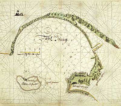
The earliest nautical charts are known as Portland charts from the 14th to 17th centuries, specifically designed for mariners, featuring numerous bearings. Mariners rely on these bearings and compasses to determine their vessel’s direction at sea. The charts also depict coastlines, bays, islands, capes, shoals, and nearshore mountain ranges, helping mariners identify navigational aids.
Modern nautical charts are much more complex than the Portland charts. In addition to maritime routes, they include hydrological factors of the sea, seabed topography, nearshore geomorphology, obstacles, maritime stations, lighthouses, ports, straits, islands, wind directions, bearings, and more.

Tafelbaai Nautical Chart from 1675 (Photo: digital-fine-art)
The hydrological factors of the sea include water depth, tides, ocean currents, whirlpools, icebergs, and the boundaries of ice. Seabed topography comprises seamounts, submerged rocks, and oceanic trenches. Obstacles primarily consist of submerged rocks, reefs, hazardous routes, shipwrecks, fishing gear, and minefields. Maritime aids include navigational beacons, lighthouses, light towers, and markers.
Today, there are many types of nautical charts such as general maritime charts, oceanic charts, nearshore (coastal) charts, coastal maps, and bay maps, all collectively referred to as nautical charts.


