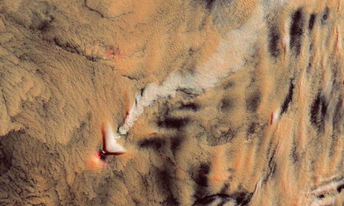
In the image captured by the Landsat 8 satellite, the long white streak above Mount Michael is difficult to distinguish as either a unique cloud or a typical plume of smoke.
Michael, a stratovolcano nearly 1,000 meters high, remains active and is more familiar to penguins than to humans. This mountain is located on Saunders Island in the South Sandwich Islands, approximately 1,600 km from Antarctica and 2,400 km from South America, with no settlements nearby. When observed from space, the mountain is often obscured by clouds.
In the image taken on November 7 by the Landsat 8 satellite, a bright white streak stands out above the island. This could be the plume from Mount Michael or a type of cloud known as a “volcanic plume.”

Landsat 8 satellite image of Mount Michael, Saunders Island. (Photo: Lauren Dauphin/USGS)
Volcanic plumes occur when clouds pass through and interact with gases and particles emitted from the volcano. These particles create additional small cloud droplets, making the cloud appear brighter. “As the cloud moves over the volcano, the imprint of these small droplets remains in the cloud, resembling a stream or a pathway with unusual texture when viewed from above,” explained Santiago Gassó, an atmospheric scientist at NASA. Gassó frequently searches for volcanic plumes in satellite images and was the one who discovered the white streak in the Landsat 8 photograph.
In natural color images, it is very challenging to recognize volcanic plumes. The Landsat 8 satellite image is in false color, created by combining shortwave infrared with blue light, helping to distinguish it from the rest of the cloud layer.
Volcanic plumes are valuable tools for scientists to detect weak volcanic activity such as steam emissions, small particles, and gases. These activities are quite common but often go unnoticed because eruptions typically occur below or within clouds. By studying the clouds surrounding such weakly active volcanoes, scientists can gain insights into cloud formation and development.
However, there is also a possibility that material from Mount Michael on November 7 rose above the cloud layer, meaning it could simply be a typical volcanic plume rather than a volcanic trail. Without LiDAR data to measure the height of the white streak, it is impossible to determine whether it is a volcanic plume or smoke.
“Landsat satellite images contain a wealth of detail. I observed a few shadows indicating what I think is a volcanic plume may just be a smoke column sitting right above the cloud layer, low enough to cast a faint shadow. But it is also quite unusual for a smoke plume to maintain such structure above the clouds without dispersing or spreading out,” Gassó noted.
Additionally, the satellite image also features a fluffy white lens-shaped cloud. This type of cloud is unrelated to volcanic activity. They can develop at the tops of atmospheric waves, forming when winds encounter a topographical barrier and are forced to change direction upwards.


