This area is home to the largest population of sea turtles in Vietnam, with the two most common species being the green turtle and the hawksbill turtle. There are 17 recorded sandy beaches that serve as nesting sites for turtles, with four of these beaches reporting around 1,000 nesting female turtles annually.
Questions
1. Which locality is named after a woman?
A. Bà Rịa City
B. Hải Phòng City
C. Huế City
2. Does Bà Rịa – Vũng Tàu Province have the largest oil reserves in Vietnam?
A. Yes
B. No
3. What is the current provincial capital of Bà Rịa – Vũng Tàu?
A. Bà Rịa
B. Vũng Tàu
4. Is Côn Đảo County a single island or an archipelago?
A. A single island
B. An archipelago
5. How many hectares of mangrove forest are currently in Côn Đảo National Park?
A. 30
B. 31
C. 51
6. Is Côn Đảo currently the area with the most sea turtles in Vietnam? True or False?
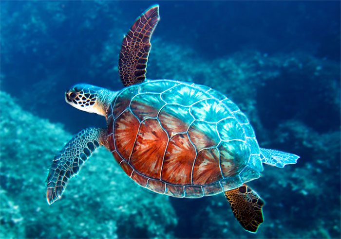
Sea Turtles.
7. Which county in Bà Rịa – Vũng Tàu is famous for Long Hải Beach?
A. Châu Đức
B. Xuyên Mộc
C. Long Điền
8. Which locality did Côn Đảo formerly belong to?
A. Bà Rịa – Vũng Tàu
B. Kiên Giang, Hậu Giang
C. Both of the above
Answers
1. The correct answer is option A: Bà Rịa – Vũng Tàu Province currently has two cities: Vũng Tàu and Bà Rịa, with Phú Mỹ Town established in April 2018 based on Tân Thành District and five counties: Châu Đức, Côn Đảo, Đất Đỏ, Long Điền, and Xuyên Mộc. According to the book “Monographie de Baria” by a French author written in 1902, the name Bà Rịa comes from a woman named Nguyễn Thị Rịa, who was instrumental in clearing the land and establishing Phước Liêu Village in 1789. Historically, this area was known as Mô Xoài or Muỗi Xụy, where the first Vietnamese settlers from Central Vietnam came to develop the southern land. Folklore recounts that in the 18th century, Nguyễn Thị Rịa from Phú Yên – Bình Định came to cultivate this land. She invested in hiring people to clear land, establish villages, and open many farms. She treated newcomers very well, earning their affection. In 1803, Rịa passed away, and since she had no children, her assets were left to the people of Tam Phước. In gratitude, they built a temple in her honor and named the region after her. Today, her tomb remains on Tam Phước Mountain (also known as Cố Mountain).
2. The correct answer is option A: The oil and gas reserves of Bà Rịa – Vũng Tàu are mainly located in the Cửu Long Basin and the Nam Côn Sơn Basin. The Cửu Long Basin includes major fields such as Bạch Hổ, Rồng, Hồng Ngọc, and Rạng Đông. The Nam Côn Sơn Basin has fields like Đại Hùng, Lan Tây, Lan Đỏ, Thanh Long, Mộc Tinh, and Rồng Bay. Oil exports significantly contribute to the GDP of Bà Rịa – Vũng Tàu. Additionally, the region has strengths in port services, industrial zones, tourism, and transportation.
3. The correct answer is option A: Bà Rịa – Vũng Tàu has over 1.1 million inhabitants with eight administrative units: Bà Rịa City, Vũng Tàu City, Phú Mỹ Town, and the counties of Châu Đức, Long Điền, Đất Đỏ, Xuyên Mộc, and Côn Đảo. According to the Bà Rịa – Vũng Tàu portal, the province was established in the 17th century, originally called Bà Rịa. Historically, this land was inhabited by a woman named Rịa from Bình Định, who came to cultivate and settle. To honor her, the local people named the area after her. Bà Rịa – Vũng Tàu is a coastal province in the Southeast region, covering 1,989 km². According to the Ministry of Planning and Investment, Bà Rịa – Vũng Tàu has various mineral resources, the most significant being oil, natural gas, and construction materials. In the total verified oil and gas reserves as of 2000, Bà Rịa – Vũng Tàu’s waters hold 400 million m³ of oil, accounting for 93.29% of the country’s reserves; gas is over 100 billion m³, representing 16.2% of the national gas reserves. The province has undergone numerous administrative reorganizations. In 1979, the Vũng Tàu – Côn Đảo Special Zone was established by merging Vũng Tàu Town (then part of Đồng Nai Province), Long Sơn Commune, Châu Thành District of Đồng Nai, and Côn Đảo District of Hậu Giang. In 1991, Bà Rịa – Vũng Tàu Province was formed from Châu Thành, Long Đất, and Xuyên Mộc counties (of Đồng Nai) and the Vũng Tàu – Côn Đảo Special Zone. Vũng Tàu City was established and became the provincial capital. In 2012, the provincial capital moved to Bà Rịa City when it was newly established, making it the only locality with a provincial capital not being the largest urban area in the province.
4. The correct answer is option B: Côn Đảo County is an archipelago consisting of 16 islands with a total area of 76 km². The county center is located 97 nautical miles from Vũng Tàu City and 45 nautical miles from the Hau River. Côn Đảo County has strong potential for tourism development, seafood processing, port services, oil and gas, and maritime services. The coastline stretches for 200 km, featuring beautiful beaches such as Đất Dốc, Bãi Cạnh, Đầm Trầu, Hòn Cau, and Hòn Tre. The largest island in this archipelago is Côn Lôn or Côn Đảo, which spans over 51 km². Historically, it was referred to as Côn Lôn or Côn Nôn before the 20th century. The old names in English and French documents were Poulo Condor. According to ancient documents, this name has Malay origins from “Pulau Kundur,” meaning “Gourd Island.” In 1977, the National Assembly officially designated it as Côn Đảo. Previously, Côn Đảo housed a system of prisons under French and American rule, with large detention centers such as Phú Hải, Phú Sơn, Phú Tường, and Phú Bình, as well as torture cages and the governor’s house. It also features the Hàng Dương Cemetery, where 20,000 prisoners, primarily revolutionary soldiers, were buried during two resistance periods.
5. The correct answer is option B: Côn Đảo National Park currently contains approximately 31 hectares of mangrove forest and many rare species of flora and fauna. Côn Đảo National Park spans nearly 6,000 hectares on land and 14,000 hectares of water. The interrelationship between coral reefs, seagrass beds, and mangrove forests creates a favorable environment for breeding, breeding, and conserving marine species. The shallow waters around the island are also home to many rare species such as sea turtles, dolphins, and dugongs. The biodiversity of Côn Đảo’s marine area is of national significance for marine nature conservation in Vietnam. The characteristic flora of Côn Đảo includes approximately 882 species of higher plants belonging to 562 genera and 161 families, including 371 woody species, 30 orchid species, 103 climbing species, and 202 herbaceous species. 44 species were first discovered here by scientists, and 11 species were named after Côn Sơn. Some species are classified as rare, such as Chukrasia tabularis and Manikara hexandra. The terrestrial fauna of Côn Đảo has recorded 144 species, including 28 mammal species, 69 bird species, 39 reptile species, and 8 amphibian species. Some endemic animals in Côn Đảo include Finlayson’s squirrel (Callosciurus finlaysonii), black giant squirrel (Ratufa bicolor condorensis), Côn Đảo rat (Rattus niviventer condorensis, Chasen & Kloss, 1926), and Côn Đảo gecko (Cyrtodactylus condorensis). Côn Đảo is a national park with a unique terrestrial vertebrate fauna from the isolated island region, hosting many endemic species. Its marine ecosystem is also diverse and rich, with 1,321 marine species documented, including 23 species of mangroves, 127 species of algae, 7 species of seagrass, 157 species of phytoplankton, 115 species of zooplankton, and 219 species of coral, as well as 5 species of marine mammals and reptiles. 37 species are listed in Vietnam’s Red Book, with many species having high economic value, such as seafood and algae. Rare marine mammals include the blue whale (Neophon phocaenoides), the finless porpoise (Orcaella brevirostris), and the dugong (Dugong dugong). Notably, Côn Đảo is also a nesting ground for several species of sea turtles.
6. The correct answer is option A: True. Currently, Côn Đảo is the area with the most sea turtles in Vietnam, with the two most common species being the green turtle and the hawksbill turtle. There are 17 recorded sandy beaches serving as turtle nesting sites, with four of these beaches having reported around 1,000 nesting female turtles annually. Côn Đảo is also the only place in Vietnam where a population of dugongs (Dugong dugong) exists, living in close association with seagrass beds. Côn Đảo National Park has been recognized by the Ramsar Convention Secretariat as one of 2,203 important international wetlands (known as Ramsar sites) and is the first marine Ramsar site in Vietnam. The national park encompasses four unique ecosystems of forests and seas that are rare worldwide. Côn Đảo serves as a convergence point and is likened to a haven for many marine species from both the northern and southern waters of the East Sea. It is also a site for biodiversity conservation (ecosystem conservation; species conservation; genetic resource conservation); serves environmental protection functions (coastal stabilization; combating sea-level rise; flood control; protecting and regulating water resources, etc.); preserves landscapes, culture, and history; and is an attractive area for various forms of ecotourism.
7. The correct answer is option C: Long Điền District has great potential for tourism development with its 14.7 km long coastline, beautiful beaches, and fine white sand. Among these, Long Hải Beach, located in Long Hải Town, Long Điền District, is 30 km northeast of Vũng Tàu City. Long Hải is famous for its natural landscape, featuring the Kỳ Vân Cape that juts into the sea and cherry blossom forests. In addition to tourism, Long Điền District has strengths in the fishing and seafood processing industries. The district’s annual fish catch is around 60,000 tons, making it the leader in Bà Rịa – Vũng Tàu. Phước Tỉnh Fishing Port is currently the largest fishing port in the province, bustling with boats coming and going. Besides seafood fishing, the port supports related services such as fuel supply, fresh water provision, ice production, boat repair, and mechanical services.
8. The correct answer is option C: Bà Rịa – Vũng Tàu has an island administrative unit known as Côn Đảo District. This archipelago is located 97 nautical miles from Vũng Tàu City and 45 nautical miles from the Hậu River, consisting of 16 islands with a total area of 76 km². Côn Đảo, often referred to as Côn Sơn, is the largest island in this archipelago. Historically, before the 20th century, this area was referred to as Côn Lôn or Côn Nôn. The old names in English and French documents were Poulo Condor. According to ancient documents, this toponym originates from the Malay language, derived from “Pulau Kundur,” which means “Squash Island.” In 1977, the National Assembly decided that the official name would be Côn Đảo. When it was first explored, Côn Đảo belonged to Hà Tiên Province (now Kiên Giang). During the administration of Ngô Đình Diệm, Côn Đảo was a province. On May 1, 1975, the troops of the National Front for the Liberation of South Vietnam took over Côn Đảo. By September 1976, Côn Đảo Province was dissolved, becoming Côn Đảo District under Ho Chi Minh City. In January 1977, this island became a district of Hậu Giang Province. In May 1979, Côn Đảo became a district within the Vũng Tàu-Côn Đảo Special Zone. This locality officially became an island district belonging to Bà Rịa – Vũng Tàu Province in October 1991.


