NASA’s satellite images reveal that not only is sea level rising, but the land where major cities are built is actually sinking.
According to the National Aeronautics and Space Administration (NASA), the rising sea levels are threatening the East Coast of the United States, but that is not the only concern.

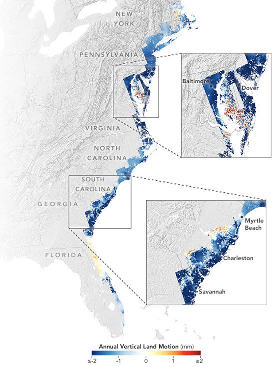
Scientists have discovered that infrastructure in major cities such as New York, Baltimore, and Norfolk, Virginia, is built on sinking land between 2007 and 2020. (Image: NASA).
The images shared by NASA on February 21 show that the coastal areas, including the land on which major cities like New York and Baltimore are built, are indeed sinking.
Through research, a team of scientists at the Innovation and Earth Observation Laboratory at Virginia Tech, funded by NASA, found that the geographical issue is “occurring quickly enough to threaten infrastructure, agricultural land, and wetlands, on which tens of millions of people along the coast depend.”
By examining satellite data and GPS sensors to track coastal movement, scientists discovered that infrastructure in major cities such as New York, Baltimore, and Norfolk, Virginia, is built on land that has been sinking from 2007 to 2020.
On average, the land here is subsiding at a rate of 1 to 2 mm per year, but in certain counties in states like Delaware, Maryland, South Carolina, and Georgia, the land is sinking 2 to 3 times faster, while land in swamp areas is sinking more than 3 mm per year. Forests are also being displaced due to saltwater intrusion and land subsidence.
According to NASA, wildlife is not the only thing affected. Along the coast, at least 897,000 buildings, including highways and airports, are located on land that is sinking.
The aforementioned findings from NASA follow another study from Virginia Tech’s laboratory, published in the scientific journal PNAS Nexus.
The maps shared by NASA were created using data from satellites from the United States, Japan, and Europe, showing that the Mid-Atlantic region is sinking more significantly. The cause is the melting of the Laurentide ice sheet that began 12,000 years ago, causing this area to sink, a phenomenon that continues to this day.

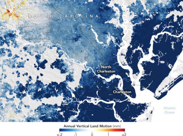
Charleston, South Carolina, is experiencing the worst subsidence, sinking about 4 mm per year. Image: NASA
One of the fastest sinking cities is Charleston, South Carolina, where the downtown area is only 10 feet (3.048 m) above sea level and is witnessing a subsidence rate of approximately 4 mm per year.
According to NASA, about 800,000 people live in this city, and part of the reason for the city’s gradual sinking is due to human activities such as groundwater extraction.
To prevent tidal flooding, the city of Charleston is considering constructing an 8-mile (12.87 km) seawall to protect the city from storm surge.
Geophysicist Leonard Ohenhen at Virginia Tech believes that the subsidence issue is “dangerous” and not given the attention it deserves compared to rising sea levels. However, it remains a significant problem, and coastal residents may face more damage to their homes, farms, and saltwater intrusion.
According to Manoochehr Shirzaei, co-author of both studies and director of the Virginia Tech laboratory, subsidence is an issue that can be locally mitigated. Groundwater extraction, as well as dams and other infrastructure, can also cause subsidence.


