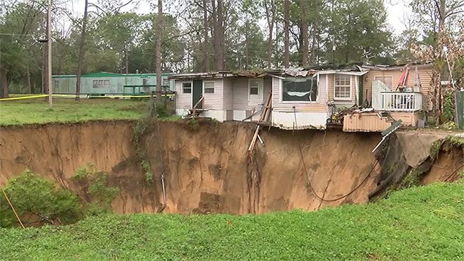
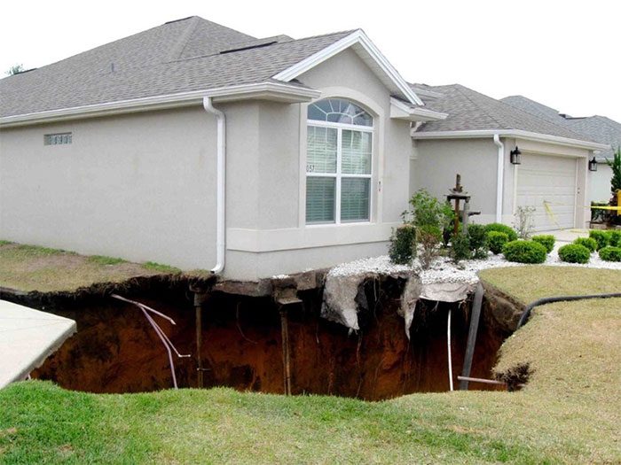
At 11 PM, Jeff Bush, who lived in the suburbs of Tampa, Florida, was asleep when the floor suddenly opened up, creating a deep hole that swallowed him. His brother jumped into the hole in an attempt to save him but was unsuccessful. In Florida, the phenomenon of “sinkholes” has become a familiar occurrence for residents.
Secrets Beneath the Ground
In February 2013, a loud crash resembling a car hitting a house echoed through the neighborhood. Moments later, screams for help filled the air as the entire bedroom of a family near Tampa was also “devoured” by a massive sinkhole. This enormous hole measured approximately 8 meters wide and over 20 meters deep. The incident resulted in the tragic death of 37-year-old Jeff Bush, who would forever rest beneath the ground. Authorities subsequently ordered residents of nearby homes to evacuate. Mike Merrill, the head of Hillsborough County at the time, remarked: “The sinkhole is very unusual – very deep, wide, and particularly unstable.”
According to the Christian Science Monitor, there are about 15,000 sinkholes throughout Florida, but most are small and rarely cause fatalities. The death of Jeff Bush due to a “sinkhole” is considered rare but has instilled significant fear among the American public.

Florida is particularly prone to sinkholes because it sits atop a massive limestone bed that is gradually eroded by groundwater. (Illustrative image)
Ginny Stevens, a local resident, told the Tampa Bay Times that she did everything she could to repair her home after the sinkhole incident, but the value of her home plummeted from $350,000 to just $125,000.
The psychological treatment costs often accompany the realization that you are living above a potential sinkhole. “If you’re living above a sinkhole, you feel stressed and anxious,” said Randazzo, a resident. “You hear cracking noises, popping sounds, groans, and creaks. You know the house is unsafe and start to wonder when it will collapse.”
Homeowners are eager to learn about sinkhole conditions to protect their interests, especially when companies can assist them in addressing the problem. For instance, GeoHazards, a company based in Gainesville, Florida, can fill sinkholes with grout. However, this service is not cheap, often costing tens of thousands of dollars. Even when sinkholes have been addressed, property values still decrease.
Unforeseen Dangers
Florida has more than 6,500 insurance claims related to “sinkholes” each year. Sandy Nettles, owner of a geological consulting firm in Tampa, noted: “Very few places in Florida escape sinkholes, and there’s no way to predict their emergence.” Most sinkhole incidents occur silently underground and suddenly burst open without any warning signs.
Scientists state that Florida is situated in a limestone bed area that is highly susceptible to erosion by acidic groundwater beneath.
Additionally, human activities can also contribute to sinkhole formation. Changes in groundwater levels – due to construction or groundwater pumping – can lead to sinkholes. Erosion creates hidden underground cavities, causing the ground above to collapse when the bedrock can no longer support the weight of the soil.
Jonathan Arthur, director of the Florida Geological Survey, explained that while other states also sit on limestone beds, Florida has additional factors such as tropical weather, heavy rainfall, and groundwater extraction activities. “These conditions allow sinkholes to develop very quickly or gradually form over time,” he stated.
Clint Kromhout, a geologist at the Florida Geological Survey in Tallahassee, wants everyone to know that there are certain things we can be sure about Florida: warm sunshine, beaches, storms, and sinkholes.
Weather is also a factor. Drought lowers water levels, while heavy rains can dump tons of water, increasing pressure on the ceilings of underground cavities and ultimately leading to soil collapse. This was evident in Florida in June 2012 when Hurricane Debby swept through after months of drought, leaving hundreds of sinkholes in its wake.
Researching Sinkhole Prediction
Kromhout and his colleague Alan Baker received $1 million in funding to create a map showing areas at risk of sinkholes. This map uses statistical methods to link evidence of past sinkholes with geological data, such as the depth of limestone or the makeup of the overlaying sediment, to predict the likelihood of sinkhole formation in specific areas.
“We go to the field to gather data into a list of geographical features,” Baker explained. “Then we input the data into a validated model by testing against existing sinkholes, and this testing yields scientifically demonstrable results.”

Most sinkholes occur silently underground. (Illustrative image).
The map displays varying levels of sinkhole risk using different colors. It doesn’t specify that a sinkhole will occur directly under your house but indicates signs to monitor continuously. “The primary goal is to help emergency management agencies prepare for upcoming storms that could create multiple sinkholes,” Kromhout stated.
However, there are concerns that residents across Florida might use this map to check whether their homes sit atop a potential sinkhole, complicating matters further. Meanwhile, some Florida residents have expressed worries about the sinkhole risk map. If it is inaccurate, it could cause unnecessary anxiety.
InSAR Technology
A potentially more effective solution for detecting sinkholes is being developed by NASA, utilizing InSAR technology (Interferometric Synthetic Aperture Radar), which can detect very slight movements in the ground. For many years, researchers at NASA’s Jet Propulsion Laboratory (JPL) have used InSAR technology to monitor the sinking coastline of Louisiana into the Gulf of Mexico.
When a “sinkhole” appeared in Bayou Corne in August 2012, swallowing the town and forcing many residents to evacuate, researchers returned to analyze radar images captured before the collapse.
They found that the ground had shifted significantly laterally by about 25 cm toward the center of the sinkhole a month before the event occurred. Monitoring similar changes in sinkhole-prone areas could contribute to forming an early warning system, helping evacuate residents before a dangerous collapse occurs.
“Not all ‘sinkholes’ exhibit surface deformation before they appear, so this method is not a magic bullet,” warned Ron Blom, a scientist at JPL and co-author of the Bayou Corne study. “But this method will certainly be effective to some extent for monitoring systems. You can obtain InSAR data for areas where sinkholes occur, and if you notice ground movement in a certain area, go to the site and see what’s happening.”
Both Blom and his co-author Cathleen Jones, who also works at JPL, acknowledge that no program similar to their warning system has been implemented in the U.S. However, Jones believes that authorities are taking the issue of “sinkholes” seriously. The problem lies not in how common sinkholes are becoming but in their detrimental effects on people and property.


