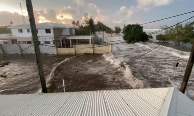
Tsunamis triggered by volcanic activity, like the disaster in Tonga on January 15, present challenges for scientists due to their complexity.
The mechanics of a tsunami caused by an earthquake are relatively familiar and predictable. However, those triggered by volcanic activity, such as the tsunami that struck Tonga on January 15, are much harder to grasp.
Satellite view of the underwater volcano erupting off the coast of Tonga. (Video: Twitter/US StormWatch)
In both phenomena, the basic principle is the same: water is suddenly displaced, creating waves. The water has no other direction to go but to spread out. However, while earthquakes cause abrupt changes, tsunamis originating from volcanic eruptions involve a more complex underwater process, including explosive eruptions, gas release, debris blasts, lava flows, and landslides.
The risks from volcanic tsunamis can also last longer. After an earthquake, underwater aftershocks may continue to shake for weeks. However, following a volcanic eruption, disturbances can agitate calm seas for months or even years.
The eruption on January 14 was caused by an underwater volcano off the coast of Tonga, approximately 8,500 km southwest of San Francisco, USA. The large waves reached Northern California about 12 hours later, coinciding with high tide. This is why residents in Hawaii, Alaska, and the Pacific coast of the United States were advised to evacuate or stay away from the shoreline and to pay attention to updates from local authorities.

The tsunami reaching Tongatapu, the largest island of Tonga. (Photo: Twitter/Sakaki Moana)
“There’s a lot going on with the volcano. There are many more physical processes, so it’s very hard for us to really know how the water will behave and what we will witness,” said Nathan Wood, a geographer monitoring research at the Western Geographic Science Center of the U.S. Geological Survey (USGS).
“A huge gas bubble rises, it’s catastrophic. The ocean ‘burps’ and that burp contains rocks and ash,” he described.
Tsunamis caused by volcanic eruptions are relatively rare, with fewer than 100 recorded cases in over two centuries. One of the most recent disasters occurred in 2018, when a large section of the volcanic island Anak Krakatau in Indonesia collapsed into the sea, flooding low-lying areas of Java and Sumatra and resulting in approximately 400 fatalities.
Most tsunamis are caused by earthquakes, not volcanoes. In the United States, most are triggered by the formation of new islands in the Aleutian chain off Alaska. However, on a planet where 2/3 of the surface is covered by water and is continuously seismically active, many coastal residents face risks.
Severe tsunami hazards exist along every coastline facing open waters and large, relatively young volcanic islands, according to a study published in a 2003 journal on megatsunamis by German scientists Franziska Whelan and Dieter Kelletat.
Forecasting volcanic eruptions is a challenge. While experts have a complex global network of seismic stations to monitor earthquakes and estimate average recurrence intervals, volcanoes are much harder to predict, especially when they are quiet, according to Wood.
It becomes even more difficult when the volcano is underwater. To monitor volcanoes on land, scientists can place sensors on the slopes. “But you can’t use those devices to monitor underwater. The work is really challenging,” Wood noted.
Whether caused by a volcano or an earthquake, the journey of a tsunami is tracked using similar tools. In the United States, the waves are closely monitored by the National Tsunami Warning Center as they spread across the ocean. The travel time depends on the depth of the seafloor, and scientists have this data. Therefore, they can often predict when a tsunami will reach a specific coastline, but only after knowing the time and location of the volcanic eruption.
The U.S. National Tsunami Warning Center consists of a network of 39 stations, known as the Deep-ocean Assessment and Reporting of Tsunamis (DART), worth $12 million, located on ocean floors worldwide. The system was established in 1986 after a false tsunami warning in Hawaii and was upgraded following the 2004 Indian Ocean tsunami that claimed over 200,000 lives.
DART’s underwater sensors are anchored on the ocean floor, sensing changes in water pressure, and then sending this information via acoustic waves to a buoy. The buoy transmits data to coastal warning centers through satellites.
Tonga was the most directly affected by the recent volcanic eruption. On January 15, water quickly inundated coastal areas of the capital Nuku’alofa on Tongatapu, Tonga’s largest island. In the coastal regions of the western United States and Hawaii, the water rose a few hours later. Wood stated that while these waves were not as high and powerful, they still posed dangers, especially in harbors.


