We are making progress in predicting “monster” storms, but it is still challenging to forecast them early enough for adequate preparation.
When satellites started sending images of Hurricane Lee—a significant storm currently traversing the Atlantic Ocean—meteorologists knew they were witnessing a “beast” storm.
Wind Explosions
In 2023, Hurricane Lee was the third storm to gain unprecedented strength. On September 7 alone, the wind speed within Lee more than doubled, escalating it from a Category 1 hurricane with winds of 129 km/h to a Category 5 hurricane with winds of 266 km/h.
Such explosive wind patterns are becoming increasingly common in certain areas.
Scientists agree that the Earth is warming and will generate more storms like Lee. These “monster” storms have the potential to double their strength before making landfall in coastal communities.
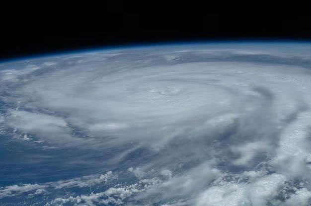
Before making landfall on September 21, 2022, Hurricane Ida’s wind speed increased by 64 km/h in just a few hours. (Image: NASA).
A study published in August in the journal Nature revealed that within a 402 km stretch of the Atlantic coastline, the number of rapidly intensifying storms has significantly increased compared to 40 years ago and is becoming more common.
Examples include Hurricane Ian in 2022 and Hurricane Michael in 2018, which escalated from Category 2 to Category 5 in just one day before striking Florida. These storms claimed numerous lives and caused $25 billion in damages. They represent the worst nightmares for meteorologists.
The Formula for a Storm
The development of any storm depends on the right environmental conditions. If the ocean water beneath the storm is warm enough, it will release a substantial amount of energy when it evaporates, resulting in a drop in air pressure and generating strong winds.
But what distinguishes a gradually intensifying storm from one that rapidly strengthens?
Brian Tang, an atmospheric scientist from the University at Albany (USA), explained: “The environmental factors need to develop simultaneously to trigger rapid wind growth.”
Just before Hurricane Lee explosively intensified, Tang sensed that things were about to escalate due to images of swirling ice crystals and rain within the storm.
Models like the Hurricane Analysis and Forecast System (HAFS) at the National Oceanic and Atmospheric Administration (NOAA) had also predicted this storm’s rapid intensification about 24 hours in advance.
More detailed measurements are also assisting forecasters. Taking Hurricane Michael in 2018 as an example, a study in 2020 showed that satellite data and measurements from buoys in the Gulf of Mexico indicated a heat wave occurring at sea as the storm approached.
Additionally, researchers are increasingly using drones to enter the lower and most dangerous parts of the storm, known as the boundary layer, to collect valuable data on storm intensity.
Ruby Leung, an atmospheric scientist at the Pacific Northwest National Laboratory of the U.S. Department of Energy, noted that the ocean’s influence on tropical storms can be quite complex.
For instance, if freshwater from rivers flows into the ocean, creating a layer of warm water above the denser, saltier water below, this can allow storms to continue intensifying.
In general, storms tend to produce more rainfall as air temperatures increase, enhancing the likelihood of storm intensification, Leung added.
Understanding these environmental nuances will be crucial for scientists to improve their predictions of increasingly dangerous storms.
