This year’s rainy season in the North is occurring with greater severity. In July alone, continuous rain and floods have resulted in dozens of fatalities. August is expected to continue being a peak period for rain and floods in the North.
Intense Rain and Floods Right from the Start of the Season
The National Center for Meteorological and Hydrological Forecasting has noted that August will continue to be a peak period for rain and floods in the North. The situation may be even more serious than in previous years due to the increasingly evident La Niña phenomenon. Currently, cold currents from deep in the Eastern Pacific Ocean are surfacing, creating a cooler-than-normal water region along the equator from the East to the central Pacific. According to data from the National Oceanic and Atmospheric Administration, July this year in the central Pacific has recorded a temperature drop of at least 0.2 degrees Celsius compared to the average of previous years.
These colder currents push warmer water towards the West Coast of the Pacific, closer to Asia, resulting in average sea temperatures here that are 1-2 degrees Celsius higher in some areas. This is an early indication that El Niño is gradually transitioning to La Niña, which has been the cause of the recent storms and intense rainfall.

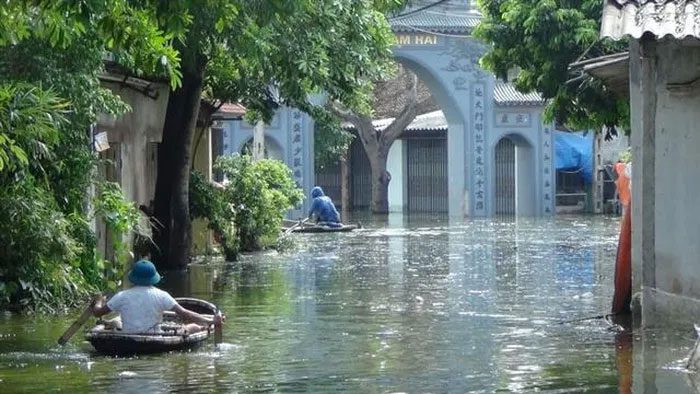
Historic floods submerged Chuong My district for many days.
In fact, in Northern Vietnam, the total rainfall since the beginning of the rainy season has been 30-80% higher than the average of previous years, with some areas experiencing increases of 80-100%. Notably, in Bac Quang, Ha Giang, and Quang Ha, Quang Ninh, the rainfall in June alone reached 1105 – 1271mm, double that of the same period last year.
Continuous heavy rain has triggered a series of landslides and severe flash floods. Additionally, floods have occurred more frequently. From June until now, there have been three moderate to large flood waves in the Northern rivers. Many rivers have reached warning levels 2 and 3, including the Gam River, Lo River (in Ha Giang), Nam Pan River, Ma River (Son La), Day River (Phu Ly), and Nam Muc River (Dien Bien).
Most notably, the flood from July 23-26 was influenced by Typhoon No. 2, leading to the continuous release of water from several major hydropower reservoirs. Hoa Binh Hydropower Plant opened 4 bottom sluices, Son La Hydropower opened 1 bottom sluice, and Lai Chau Hydropower opened 5 surface sluices. Consequently, the flood levels in the Northern Delta rose high, with the water level on the Red River in Hanoi exceeding last year’s peak flood level. The Bui River through Chuong My, Hanoi remains inundated with widespread flooding.
Mr. Nguyen Van Huong, Head of the Weather Forecasting Department at the National Center for Meteorological and Hydrological Forecasting, stated that August will continue to be the peak period of the rainy season in Northern provinces due to the influence of La Niña. The total rainfall in the Northern region is expected to be approximately at the average level of many years, with rainfall in the Northern mountainous and northeastern areas ranging from 300-400mm, and some areas exceeding 500mm. In the plains and midland regions of Northern Vietnam, rainfall is expected to fluctuate between 250-350mm, with some areas over 400mm. Due to the potential for heavy rainfall events, there is a high risk of flooding in low-lying areas and dangerous landslides in mountainous regions.
Complex and Unpredictable Causes of This Rainy Season
According to the general pattern, the annual rainy and stormy season in our country typically occurs from July to December. However, the 2024 rainy and stormy season is anticipated by the national meteorological agency to be complex and unpredictable due to the influence of La Niña.
Analyzing La Niña, Mr. Nguyen Duy Chinh, Deputy Director of the Meteorological Institute, pointed out that La Niña is a phenomenon of cooling sea surface temperatures in the central Pacific, which leads to increased rainfall and humidity over land areas. As a result, Vietnam and countries in the Indochina Peninsula will experience more rain and floods than usual. According to Mr. Chinh, the occurrence of La Niña will also impact the mechanisms of storms, but this issue requires specific research to draw accurate conclusions.
According to the National Center for Meteorological and Hydrological Forecasting, around September, Vietnam will be affected by La Niña, leading to very complex developments of rainstorms in the Central provinces. From now until October, there is a possibility of 6-8 storms or tropical depressions forming over the East Sea, with about 2-4 making landfall. This number is slightly higher than the average of many years, during which typically 6-7 storms operate over the East Sea, with 3 making landfall in our country.
Additionally, rainfall levels around July-August are expected to be close to the average of previous years for this period. However, from September to November, rainfall in the Northern region is expected to increase by about 10-30%. Thus, heavy rainfall will become concentrated towards the end of the year, particularly in the Central region, increasing the risk of prolonged flooding, widespread inundation, flash floods, and landslides. High rainfall will exacerbate localized flooding and urban inundation.
Dr. Le Thi Xuan Lan – a meteorological forecasting expert, advises that storms forming over the East Sea are often more dangerous because there is less time to prepare. Therefore, early warning is essential to minimize potential damages. This year, due to the presence of La Niña, the rainy and stormy season may extend into the late months of the year. Historically, storms that have significantly affected Vietnam often occur in the latter part of the year and make landfall in the southern provinces, which also have less experience in storm response, necessitating special attention.
|
ENSO is a natural phenomenon that severely impacts the global climate system. ENSO includes two opposing phases: El Niño and La Niña, with transitions between these phases occurring periodically every 2 to 7 years. Under conditions of global climate change, ENSO is exhibiting abnormal patterns in intensity and frequency, affecting rainfall, drought, flooding, and temperature. El Niño refers to the abnormal warming of sea surface waters in the central and eastern Pacific equatorial region, lasting 8-12 months (or longer), typically occurring every 3-4 years, but can sometimes occur more frequently or less frequently. La Niña (the opposite of El Niño) is the phenomenon where sea surface temperatures in the aforementioned region cool abnormally, occurring with a similar or less frequent cycle than El Niño. The cycle of La Niña is typically longer and causes weather patterns that are opposite to those of El Niño. |


