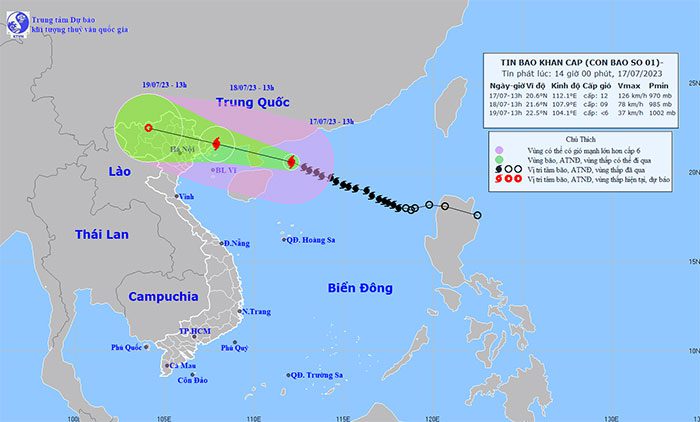
At 1 PM on July 17th, the center of Typhoon No. 1 was located approximately 480 km East-Southeast of Mong Cai (Quang Ninh). The maximum wind speed near the center of the typhoon was categorized as level 12 (118-133 km/h), with gusts reaching level 15.
According to the National Center for Hydro-Meteorological Forecasting, by 1 PM on July 18th, Typhoon No. 1 was moving in a West-Northwest direction, at a speed of about 20 km/h towards the coast of Quang Ninh-Haiphong. Wind strength was at level 9, with gusts reaching level 12.
At 1 PM on July 19th, the typhoon continued its West-Northwest trajectory at 15-20 km/h, moving inland and weakening into a tropical depression, before dissipating gradually over the western mountainous region of Northern Vietnam.

Typhoon No. 1’s position and direction of movement. (Source: nchmf).
As a result of Typhoon No. 1, the northern part of the northern East Sea was experiencing strong winds of levels 8-9, with near the typhoon’s center reaching levels 11-12, and gusts at level 15. The sea was extremely turbulent.
From the afternoon of July 17th, the northern Gulf of Tonkin (including the island districts of Bach Long Vy and Co To) saw winds gradually strengthen to levels 6-7, increasing to levels 8-9, with the area near the typhoon’s center reaching levels 10-11 and gusts at level 14. The sea remained extremely turbulent.
On land, from early morning on July 18th, coastal areas from Quang Ninh to Thai Binh experienced gradually strengthening winds of levels 6-7, with areas near the typhoon’s center at levels 8-9 and gusts at level 12; provinces such as Lang Son, Bac Giang, and Bac Ninh experienced winds of levels 6-7 with gusts at level 9.
The northern waters of the northern East Sea had wave heights of 6.0-8.0 meters.
Starting from the morning of July 18th, the Gulf of Tonkin saw increasing wave heights of 2.0-4.0 meters, with the northern part reaching 3.0-5.0 meters. Coastal areas in Quang Ninh and Nam Dinh had wave heights of 2.0-3.0 meters.
In the coastal areas of Quang Ninh-Haiphong, storm surge levels were expected to reach 0.4-0.6 meters. There is a high risk of flooding in low-lying areas along the coast, river mouths, and coastal erosion due to the combined effects of high tides and large waves on the afternoon of July 18th.
From the night of July 17th to July 19th, heavy to very heavy rainfall was expected in the Northeast and Viet Bac regions, with common rainfall amounts ranging from 200-300 mm, and localized areas exceeding 400 mm; the Northwest and the northern delta region would experience heavy rainfall with totals from 150-250 mm, while Thanh Hoa and Nghe An provinces would see moderate to heavy rain, with some areas receiving very heavy rainfall between 70-150 mm, and localized areas exceeding 250 mm. Caution is advised for intense rainfall that may cause urban flooding. There is a high alert for flash floods and landslides in the provinces of Quang Ninh, Lang Son, Cao Bang, Ha Giang, Lao Cai, and Yen Bai.


