Thanks to the use of LiDAR, archaeologists have discovered thousands of ancient structures and settlements of the Maya civilization, including towers, temples, and roads.
According to Live Science, geologists in northern Guatemala have employed LiDAR – a remote sensing technology that uses laser beams and sensors to measure the reflected rays, enabling the identification of hidden anomalies on the ground obscured by tree canopies or modern objects – to survey a rainforest believed to have been inhabited by the ancient Maya.
This technology is particularly advantageous in areas like the tropical forests of the Mirador-Calakmul Karst basin in Guatemala, where laser beams can penetrate thick canopies.
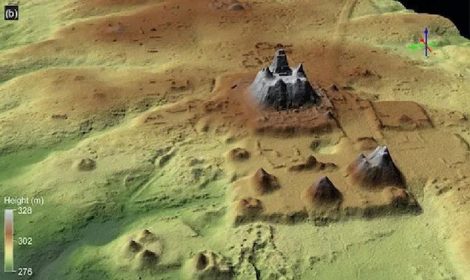
A large pyramid and surrounding structures revealed through the survey – (Photo: ANCIENT MESOAMERICA)
The data from the scans exceeded all expectations, revealing over 1,000 settlements scattered across a rainforest area of about 1,700 km2, linked by 100 km of elevated roads carefully constructed by the ancient Maya for walking.
In addition to residential areas, remnants of large pyramids, canals, and reservoirs were also found among these “ghosts” of the Maya time.
These discoveries not only unveil a new world and a historical period but also provide further evidence of the “timeless” scientific and engineering prowess of the Maya, particularly in infrastructure development that catered to a lifestyle only slightly less advanced than modern times.
The dating of these structures adds to the astonishment of the findings: they date from 1000 BC to 250 BC, belonging to the Middle and Late Preclassic periods of Maya civilization.
The extent of the settlements and their interconnections promise to yield significant insights into how the ancient Maya lived and traded.
“For the first time, data about a region has been integrated regarding politics and economy, something previously unseen in other parts of the Western Hemisphere,” said co-author Carlos Morales-Aguilar from the Department of Geography and the Environment at the University of Texas at Austin. “Now we can see the entire landscape of the Maya region in this part of Guatemala.”
So, what made this area so appealing that the Maya chose to settle here from the very beginning?
Co-researcher Ross Ensley, a geologist at the Lowland Maya Geological Research Institute in Houston, USA, noted: “For the Maya, the Mirador-Calakmul limestone basin is the ‘Goldilocks Zone.’ The Maya settled in this area because it provides the right combination of highlands for habitation and lowlands for agriculture. The highlands offer limestone, their primary building material. The lowlands are primarily wetlands, favorable for agriculture in flooded areas as well as rich organic lands for use in terrace farming.”
Researchers have previously used LiDAR to scan Maya sites in Guatemala. In 2015, an initiative called “The Mirador Basin Project” conducted two large-scale surveys in the southern part of the basin, focused on the ancient city of El Mirador. This project led to the mapping of 1,703 km2 of the region in Guatemala, according to research findings.
Morales-Aguilar stated: “When I created the first models of the cleared land of the ancient city of El Mirador, I was overwhelmed. It was fascinating to observe for the first time such a large number of reservoirs, grand pyramids, terraced fields, residential areas, and small mounds.”
Researchers hope that LiDAR technology will aid them in uncovering parts of Guatemala that have remained a mystery for centuries.


