On February 6, two consecutive earthquakes with magnitudes of 7.8 and 7.5 struck the border region of Turkey and Syria, causing severe damage. This dual disaster has led to a humanitarian and economic crisis. Specifically, thousands of people in Turkey and Syria have been reported dead, and many more remain unaccounted for.
This is not the first time Turkey and Syria have experienced devastating earthquakes. Experts suggest that it will not be the last time earthquakes occur in this region.

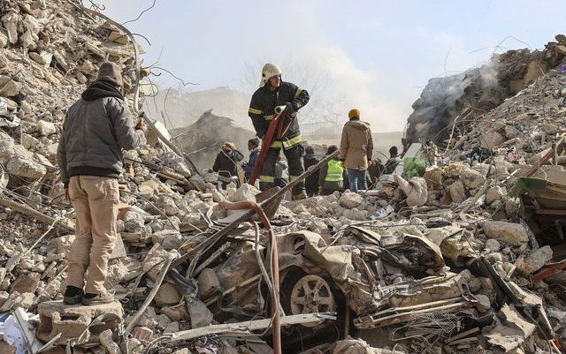
Over 34,000 people have died following the earthquake that struck Turkey and Syria on February 6 (as of noon, February 13). (Photo: Getty Images)
The cause lies deep beneath the Earth’s surface, where three tectonic plates converge. These tectonic plates create a unique type of earthquake with a high potential for destruction.
<pSpecifically, the first earthquake occurred about 18 km below the town of Gaziantep, Turkey. Initially, it seemed that 18 km was a considerable depth. However, this is still considered shallow for a major earthquake.
<pExperts indicate that this town is particularly vulnerable to damage due to its proximity to the intersection of two tectonic plates.
What are tectonic plates?
Tectonic plates are massive slabs of rock that make up the Earth’s crust, ranging from 16 to 260 km in thickness, and they are always moving slowly.
Dr. Michael Steckler from Columbia University (New York, USA) stated: “We can divide the Earth into large plates. They are all moving around each other. Most earthquakes occur at the boundaries between these plates.”

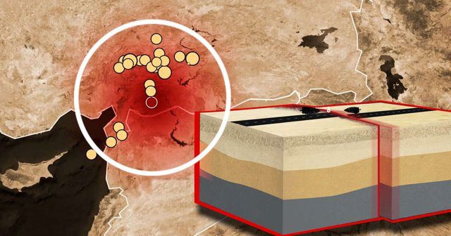
Turkey frequently experiences earthquakes due to being situated between two large tectonic plates. (Photo: WSJ).
Turkey is positioned between two major tectonic plates, making earthquakes a common occurrence. The three tectonic plates involved are the Anatolian Plate, the African Plate, and the Arabian Plate, which slide against each other. The Anatolian Plate moves westward, while the African and Arabian Plates move eastward.
The boundaries between these tectonic plates are referred to as transform faults. The conflict between the plates increases as they are pushed in different directions. When the conflict level becomes too great, they slip, resulting in a transform earthquake. At this point, pressure builds up and is ultimately released, causing a significant earthquake.
This is exactly what happened in Gaziantep, leading to the 7.8 magnitude earthquake.
According to the U.S. Geological Survey (USGS), the slip occurred along approximately 160 km of the fault line. This distance is about 30 km shorter than most transform earthquakes.
Researchers suggest that significant earthquakes along this fault system may result from the accumulation of pressure over 300 to 500 years since the last earthquake. Notably, the energy released during this transform earthquake may be comparable to the energy emitted from the eruption of Mount St. Helens in 1980.
A similar event occurred 9 hours later in Ekinozu (Turkey), resulting in the 7.5 magnitude earthquake, which struck at a depth of only 10 km.
In total, more than 285 aftershocks occurred following the two earthquakes. USGS experts have noted that the earthquake area is unstable and has significant tectonic activity. This region is considered one of the most complex in the world regarding tectonics, as it involves four different tectonic plates interacting.
Historically, areas with complex tectonics have caused terrifying earthquakes. For instance, the North Anatolian Fault, spanning 965 km, has caused seven significant transform earthquakes from 1939 to 1999. Among these, the 1999 earthquake, which registered a magnitude of 7.4, resulted in approximately 17,000 fatalities.
Meanwhile, the USGS recently estimated that, economically, the earthquake that struck Turkey and Syria on February 6 could result in billions of dollars in losses. The most severe impact is the loss of life and destruction. In reality, this region will take many years to recover.
However, there is concern about whether the two recent earthquakes could potentially “trigger” a third one?
Experts are also uncertain about this. Whether the dual disaster adds pressure to nearby faults or relieves pressure will require more time to determine.
Furthermore, due to the convergence of three tectonic plates, the issue is not whether another earthquake will occur but rather when it will happen.
What do NASA satellites observe?
According to data shared by NASA, the two consecutive earthquakes in the border region of Turkey and Syria originated from a fault line located 18 km below the surface, creating significant tremors that affected areas hundreds of kilometers from the epicenter.
Geophysicist Eric Fielding at NASA’s Jet Propulsion Laboratory stated: “These are very large and powerful earthquakes. They broke the entire surface along a series of long fault segments. This created extremely strong tremors over a vast area, impacting many densely populated cities and towns.”

Rescue teams are still working to find survivors following the 7.8 magnitude earthquake. (Photo: Getty Images)
According to this expert, the length and intensity of the 7.8 magnitude earthquake are similar to the earthquake that devastated San Francisco in 1906.
As of noon on February 13, according to CNN, it is estimated that over 34,000 people have died and approximately 10,000 have been injured following the 7.8 magnitude earthquake that struck Turkey and Syria on February 6.

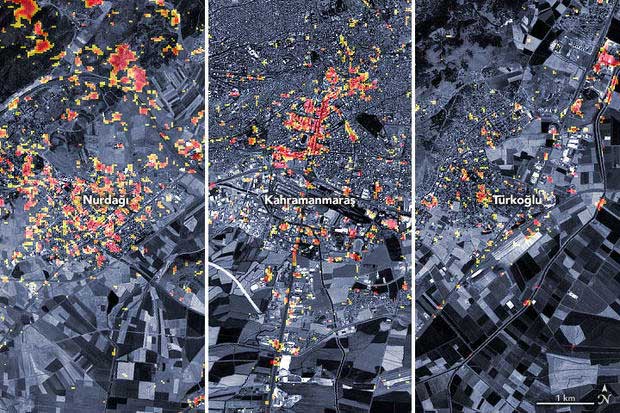
The NASA satellite map shows the extent of damage in three Turkish cities after the February 6 earthquake. (Photo: NASA).
After learning about the earthquake disaster in these two countries, NASA scientists and space agencies worldwide began collecting, processing, and analyzing satellite data related to the event.
The satellite map provides a preliminary overview of the damage in parts of the cities of Türkoğlu, Kahramanmaraş, and Nurdaği in Turkey. Areas highlighted in dark red represent locations with severely damaged infrastructure or altered landscapes. Additionally, regions in orange and yellow indicate moderate or partial destruction. In reality, each pixel represents an area approximately 30 meters in size, about the size of a baseball field.
This map was created using data collected by the PALSAR-2 device on the Advanced Land Observing Satellite ALOS-2 on February 8, 2023. This satellite carries a synthetic aperture radar, a sensor that emits microwave pulses towards the Earth’s surface and listens for the reflection of these waves to map the landscape.
Scientists can observe changes and identify damaged areas by comparing data from February 8 with observations from the same satellite prior to the earthquake in April 2021 and April 2022.
This damage map and satellite data are being shared with organizations such as the U.S. Department of State, Miyamoto Global Disaster Relief, and the World Bank. Additionally, the NASA team is participating in ongoing coordination programs organized by the U.S. Agency for International Development to contribute scientific expertise to support risk assessment and recovery efforts.


