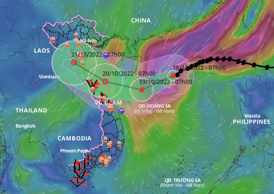
At 7 AM this morning, the center of Typhoon Nesat was located approximately 310 km from the Paracel Islands, with maximum winds of 149 km/h (Category 13), an increase of one category compared to yesterday afternoon.
The National Center for Hydro-Meteorological Forecasting reported that today, the typhoon continues to move slowly at about 15 km/h, trending southward. By 7 AM tomorrow, the center of the typhoon will be north of the Paracel Islands of Vietnam, with wind speeds decreasing to Categories 10-11, gusting to Category 13.
Afterwards, the typhoon will maintain its course, and due to interaction with cold air from the north, its intensity will decrease rapidly. By 7 AM on October 20, the center of the typhoon will be 120 km north of Quang Binh and 150 km southeast of Ha Tinh, weakening into a tropical depression with wind speeds reduced to 61 km/h, Category 7, with gusts increasing by two categories.
At the meeting of the National Steering Committee for Disaster Prevention this morning, Mr. Mai Van Khiem, Director of the National Center for Hydro-Meteorological Forecasting, presented two scenarios for the typhoon.
The first scenario has a 60-69% probability that the typhoon will interact with cold air, weakening into a tropical depression or low-pressure area before entering the Central region’s waters.
The second scenario has a 30-40% probability that the typhoon will reach south of Hainan Island, interacting strongly with cold air, dissipating before making landfall. The inland areas will experience minimal rain and wind.

Expected path and impact area of the typhoon, 7 AM on October 18. (Photo: General Department of Disaster Prevention)
The Japan Meteorological Agency believes that Typhoon Nesat has reached its peak intensity with winds of about 145 km/h, maintaining this strength as it approaches the Paracel Islands. By the evening of October 19, as it nears the coast of Vietnam, the wind speed will reduce to 100 km/h, Category 10; it will further weaken as it makes landfall in the provinces from Ha Tinh to Quang Binh.
The Hong Kong Observatory predicts that the typhoon will gradually lose strength as it crosses the Paracel Islands and weaken into a tropical depression before reaching Central Vietnam. The movement direction of the typhoon is relatively consistent among both Vietnamese and international meteorological agencies.
Due to the influence of the typhoon, today the northern part of the East Sea (including the waters around the Paracel Islands) will experience stormy weather, with winds increasing from Category 9 to 12, gusting to Category 14, and wave heights reaching 6-8 m, with heights near the center of the typhoon at 8-10 m.
The northwestern waters in the central part of the East Sea will see rain showers and strong thunderstorms; winds will strengthen to Category 6-7, gusting to Category 9, with wave heights of 4-6 m. The Gulf of Tonkin and the waters from Quang Tri to Quang Nam will experience strong winds of Category 6-7, gusting to Category 8-9, with wave heights of 3-5 m.
According to the National Steering Committee for Disaster Prevention, by 6:30 AM today, local authorities had reported and accounted for nearly 60,000 fishing vessels with over 270,000 workers being aware of the typhoon’s developments. Currently, there are 3 vessels from Quang Ngai with 33 fishermen in the dangerous waters around Da Loi Island of the Paracel Islands.
In the past 20 days, the East Sea has experienced three typhoons: Noru, Son Ca, and Nesat. Most recently, Typhoon Son Ca weakened into a tropical depression and made landfall in Da Nang – Quang Nam in the early hours of October 15, causing rain from Quang Tri to Quang Ngai, with Da Nang and Thua Thien Hue experiencing the heaviest rainfall. Da Nang faced unprecedented flooding, resulting in 6 fatalities and significant losses to infrastructure and personal property, which are still being assessed.
Long-term forecasts from now until January 2023 predict that the East Sea will see about 3-5 typhoons and tropical depressions, with 2-3 potentially impacting Vietnam directly, particularly in the Central and Southern regions.


