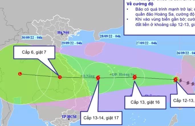
Typhoon No. 4 is moving at a very fast speed of 20-25 km/h and is forecasted to maintain wind speeds of 11-12 when it makes landfall in the Thừa Thiên – Huế to Quảng Ngãi region, with gusts reaching level 14.
According to the National Center for Hydro-Meteorological Forecasting, at 10 AM on September 26, the center of Typhoon No. 4 (Typhoon Noru) was located at approximately 16.0 degrees North latitude and 118.1 degrees East longitude, over the eastern waters of the North and Central East Sea, about 650 km east of the Paracel Islands. The strongest winds near the center of the typhoon are at level 12, with gusts at level 14. The radius of strong winds at level 6 and gusts from level 8 and above extends about 210 km from the center of the typhoon; while the radius of strong winds at level 10 and gusts from level 12 and above extends about 100 km from the center of the typhoon.

Location, movement direction, forecast intensity of Typhoon No. 4 – (Source: National Center for Hydro-Meteorological Forecasting).
Forecast for the next 24 hours: Typhoon No. 4 is expected to move mainly westward, traveling 20-25 km per hour and gaining strength. By 10 AM on September 27, the center of the typhoon will be located at approximately 15.7 degrees North latitude and 113.2 degrees East longitude, right over the southeastern area of the Paracel Islands. The maximum wind speed near the center of the typhoon will reach level 13 (134-149 km/h), with gusts at level 16.
Dangerous areas in the East Sea for the next 24 hours (winds of level 6 and above, gusts of level 8 and above): from latitude 12.5 to 20.0 degrees North; east of longitude 110.0 degrees East. All vessels operating in the dangerous areas are at high risk of being affected by strong winds, large waves, and tornadoes. The natural disaster risk level is rated at level 3.
In the next 24 to 48 hours, Typhoon No. 4 will continue to move mainly westward, traveling 20-25 km per hour and further intensifying. By 10 AM on September 28, the center of the typhoon will be located at approximately 15.6 degrees North latitude and 108.5 degrees East longitude, over the land area from Thừa Thiên – Huế to Quảng Ngãi. The maximum wind speed near the center of the typhoon will be at level 11-12, with gusts at level 14.
Warning of strong winds and high waves at sea, storm surges along the coast: The southern waters of the North East Sea (including the waters around the Paracel Islands) and the central area of the East Sea are expected to experience heavy rain and strong winds of level 8-9, increasing to levels 10-11; near the center of the typhoon, winds will be at levels 12-14, with gusts at level 16; sea waves will be 9-11 meters high; the sea will be extremely rough.
From the afternoon of September 27, the offshore waters from Quảng Bình to Ninh Thuận (including the islands of Cồn Cỏ, Cù Lao Chàm, and Lý Sơn) will experience strong winds of level 8-9, increasing to levels 10-11, with the area near the typhoon’s center experiencing winds of levels 12-14, gusts at level 16, and sea waves reaching 8-10 meters, leading to very rough seas.
Warning of strong winds on land: From early morning on September 28, coastal areas from Quảng Bình to Phú Yên will experience strong winds of level 6, increasing to levels 7-8, with gusts up to levels 9-10; coastal areas in Đà Nẵng, Quảng Nam, Quảng Ngãi, and Bình Định will experience strong winds of levels 9-10 from early morning on September 28, with areas near the typhoon’s center experiencing winds of levels 12-13, gusts at levels 14-15, while deeper inland areas will see winds of levels 8-9; gusts reaching levels 12-13; in the Kon Tum and Gia Lai areas, winds will gradually increase to level 6, then rise to levels 7-8, with some places reaching level 9, and gusts at level 11.
Warning of heavy rainfall up to 400 mm
From the afternoon of September 27 to September 28, the regions of Quảng Trị, Thừa Thiên – Huế, Đà Nẵng, Quảng Nam, Quảng Ngãi, and Kon Tum are expected to experience very heavy rain with common rainfall amounts of 250-350 mm per event, with some areas exceeding 400 mm per event; the regions of Quảng Bình, Bình Định, and Gia Lai will see common rainfall amounts of 100-200 mm per event, with some areas exceeding 300 mm per event. Starting from September 28, heavy rain is expected to spread to the North Central region and the Southern Red River Delta.


