Experts are mapping the Martian subsurface by listening to the sounds of wind reverberating through layers of soil and rock near the equator.
They are utilizing instruments on InSight, NASA’s lander that touched down on the Elysium Planitia plain in 2018, to study minor earthquakes on Mars. InSight’s data has also helped scientists form preliminary insights into the size and composition of Mars’ core, as well as the nature and thickness of its mantle and crust.
The research team, led by Swiss geophysicists, employed a new technique developed on Earth to see through Mars’ barren surface and explore areas more than 200 meters deep within the crust.
“This technique relies on the vibrations of the surrounding environment. On Earth, oceans and winds cause the ground to shake all the time. The vibrations measured at a specific point also carry signatures from below the surface,” explained Cedric Schmelzbach, a geophysicist at the Swiss Federal Institute of Technology Zurich (ETH Zurich) and a member of the research team.
Essentially, surface tremors cause the ground to vibrate. These tiny vibrations travel deep below the surface and can be detected by sensitive instruments.
Schmelzbach noted that Mars is much quieter than Earth, lacking oceans and having a much thinner atmosphere, which results in weaker winds. Moreover, while geologists on Earth can utilize countless stations, they only have one – the InSight lander – on Mars.

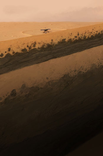
Simulation of Mars’ subsurface beneath the InSight lander. (Image: ETH Zurich/Geraldine Zenhausern).
However, listening to the interaction between the winds and the subsurface still reveals astonishing details about the structures beneath the surface of the red planet. The map provides intriguing information about Mars’ evolutionary process over billions of years. It unveils an unexpectedly deep layer of sediment and a thick layer of solidified lava, all covered by a 3-meter thick layer of sand.
The origin of the newly discovered sediment layer remains a mystery. It lies 30 to 70 meters below the Martian surface, sandwiched between two layers of ancient solidified lava. The research team compared the two lava layers with previous studies on the geology of nearby depressions. This comparison helped them determine that they formed during two significant stages in Mars’ geological history, approximately 1.7 billion years ago and 3.6 billion years ago.
Atop the younger lava layer, just beneath the surface soil, is a band of rock approximately 15 meters thick. This rock may have been ejected from the Martian surface by a meteorite impact, only to fall back down.
The new study was published in the journal Nature Communications on November 23. In the future, scientists hope to see if they can further develop their technique to look deeper, down to the first few kilometers of Mars’ crust.


