The influence of the tropical depression is causing widespread rain in the Central South, Central Highlands, and Southeast regions. Today, Ho Chi Minh City is likely to experience heavy rain, posing a risk of flooding.
On the morning of October 27, the National Center for Hydro-Meteorological Forecasting reported that due to the tropical depression, many areas in the Central South and Central Highlands experienced heavy rain overnight. Rainfall amounts were generally between 60-80 mm, with some places exceeding 100 mm.
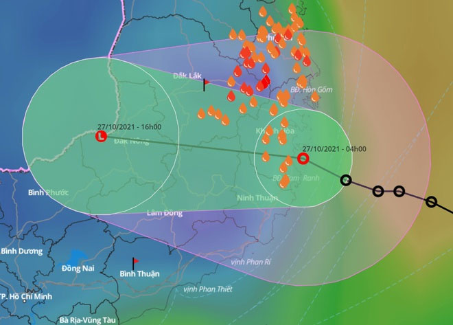
At 4 AM, the center of the tropical depression was located right off the coast of Khanh Hoa Province, with maximum wind speeds of level 6, gusting to level 8.
In the next 12 hours, this system is expected to move northwest at a speed of 10-15 km/h, entering Khanh Hoa and then weakening into a low-pressure area.
By the afternoon of October 27, the center of the low-pressure area will be located over the southern Central Highlands, with maximum wind speeds below level 6.

The tropical depression is likely to sweep directly through Khanh Hoa this morning, with its circulation affecting the entire Central South and southern Central Highlands. (Photo: VNDMS).
Today, the influence of the tropical depression’s circulation will bring heavy rain to the area from Thua Thien – Hue to Quang Ngai, Binh Thuan, northern Central Highlands, and Southeast regions, with rainfall amounts generally between 80-120 mm, and some areas exceeding 150 mm.
Meanwhile, from Binh Dinh to Ninh Thuan and southern Central Highlands, rainfall may reach 100-150 mm, with some places exceeding 200 mm. Meteorological agencies warn of the risk of flash floods and landslides in mountainous areas, as well as localized flooding in low-lying regions and along riverbanks.
According to the Southern Hydro-Meteorological Station, Ho Chi Minh City is likely to experience heavy rain today, with rainfall amounts generally between 30-50 mm, and some areas exceeding 80 mm. Heavy rain combined with high tides poses a risk of flooding.
Mr. Mai Van Khiem, Director of the National Center for Hydro-Meteorological Forecasting, stated that heavy rain will be concentrated on the night of October 26 and the morning of October 27, potentially causing localized flooding in urban areas such as Quy Nhon, Tuy Hoa, Nha Trang, and Da Lat. Meanwhile, flash floods and landslides may occur in localities from Thua Thien – Hue to Khanh Hoa, Dak Lak, and Lam Dong.
Experts warn that flood peaks on rivers from Thua Thien – Hue to Khanh Hoa and the northern Central Highlands may reach alert levels 1, 2, and above level 2. Flood peaks on some rivers in Binh Dinh, Phu Yen, Ninh Thuan, Binh Thuan, upstream of the Dong Nai River, and rivers in southern Central Highlands may reach alert levels 2-3.
“Localities in the southern Central Highlands, upstream of the Dong Nai River, and the area from Quang Ngai to Binh Thuan are at high risk of flooding,” Mr. Khiem said.
Tonight, rain will decrease in the Central South and Central Highlands but will extend northward. From the night of October 27 to October 31, the North Central, Central Central, and Northeast regions will enter a period of heavy rain due to the influence of cold air and eastern wind disturbances.
- The tropical depression is strengthening into a storm, heading directly towards the Khanh Hoa-Ninh Thuan area
- Shocking discovery: Half of the world’s rivers “evaporate” for 24 hours each year, what disaster does this hide?
- What is the tropical convergence zone? Does Vietnam experience the influence of the tropical convergence zone?


