At 6 AM on October 14, the wind speed of Typhoon Kompasu decreased to 60-75 km/h, equivalent to levels 7-8, approximately 200 km away from the coast of Thanh Hoa – Ha Tinh provinces.
Over the past 10 hours, the typhoon has weakened by one level due to friction with Hainan Island (China) and interaction with a dry cold air mass descending from the north.
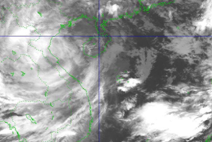
Satellite image of the typhoon at 6 AM on October 14. (Photo: NCHMF)
The National Center for Hydro-Meteorological Forecasting reported that this morning the typhoon is moving west at a speed of 20-25 km/h and is weakening into a tropical depression. By 4 PM, the center of the tropical depression will be located off the coast of Nam Dinh – Ha Tinh, with the strongest winds at 60 km/h, level 7, with gusts increasing by two levels.
After that, the tropical depression will maintain its speed, moving into the area from Thanh Hoa to Quang Binh and weakening into a low-pressure area over Central Laos.
The Japan Meteorological Agency indicates that the typhoon is currently at 82 km/h and will maintain this wind speed upon landfall. The U.S. Navy noted that the typhoon was at 83 km/h over Hainan Island (China), decreasing to 65 km/h after entering Central Vietnam.
Dangerous areas in the East Sea for the next 24 hours (winds of level 6 or higher, gusts of level 8 or higher) extend from north latitude 17; west longitude 110. All vessels operating in these dangerous areas are at high risk of being affected by strong winds, high waves, and tornadoes.
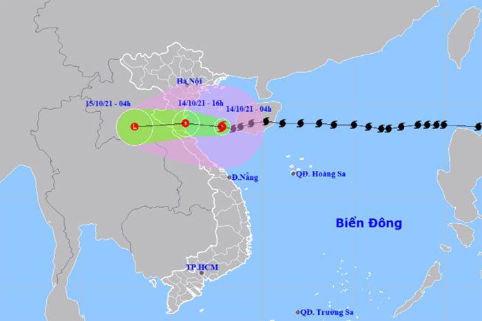
Forecast path and affected areas of the typhoon. (Photo: NCHMF)
Today, the coastal areas from Quang Ninh to Quang Binh will experience strong winds of levels 6-7, with gusts of level 9. The Gulf of Tonkin (including Bach Long Vi Island) and the waters from Quang Tri to Thua Thien Hue (including Con Co Island) will have winds of levels 6-7, with areas near the typhoon center experiencing winds of level 8, with gusts of level 11; sea waves will be 3-5 meters high.
Coastal provinces from Thai Binh to Nghe An need to be cautious about storm surges of 0.3-0.5 meters, combined with high tides causing flooding in low-lying areas.
From October 14-15, Northern Vietnam and Quang Tri will see rainfall of 100-150 mm per event, with some areas exceeding 150 mm; from Thanh Hoa to Quang Binh, rainfall will be 100-200 mm, with some areas exceeding 200 mm.
From October 16 to 19, due to the influence of enhanced cold air combined with a potential low-pressure area, Central Vietnam will continue to experience heavy rainfall. Localities need to be cautious of the high risk of flash floods and landslides in mountainous areas, as well as localized flooding in low-lying regions and riverbanks.
In response to the typhoon, several provinces in Central Vietnam have banned fishing since October 12. Many reservoirs in Nghe An, Ha Tinh, and Thua Thien Hue are releasing water to prepare for floodwaters when the typhoon’s circulation combines with cold air to cause heavy rains. A scenario to evacuate 25,000 people if the typhoon reaches level 9 has also been prepared.
Kompasu is the eighth typhoon in the East Sea; meteorological agencies predict that after this typhoon, there will be about 4-6 more typhoons and tropical depressions appearing in the East Sea, with 2-3 of them affecting Vietnam.
