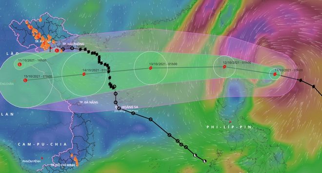
Tropical Storm Kompasu is forecasted to enter the South China Sea on October 12, bringing significant weather changes to the mainland. Before the storm arrives, heavy rainfall continues across the country, with cooler temperatures expected in the northern regions.
In the early hours of October 11, the National Center for Hydro-Meteorological Forecasting reported that Tropical Storm Kompasu, located near the South China Sea, has maintained strong winds of level 9, with gusts reaching level 11 in recent hours. As of 1 AM, the storm’s center was approximately 300 km northeast of Luzon Island (Philippines).
Throughout the day and night, the storm is moving rapidly in a west-northwest direction at a speed of 20-25 km/h and is expected to intensify. By the early morning of October 12, the storm’s center will be directly over the northwest of Luzon Island, with maximum wind speeds of level 9-10 and gusts reaching level 12.
This trajectory will then shift, as the storm moves westward into the South China Sea at a speed of 25 km/h. By the early morning of October 13, the storm’s center will be about 360 km northeast of the Paracel Islands, with maximum wind speeds of level 11 and gusts of level 13.
After this point, the storm will primarily head in a west-southwest direction at a speed of 25 km/h. By the early morning of October 14, the storm’s center will be over the southern waters of the Gulf of Tonkin, with maximum wind speeds of level 9 and gusts of level 11.
As a result of the storm, on the morning of October 11, the eastern sea area of the northern South China Sea will experience increasing winds, reaching levels 8-9, and later escalating to levels 10-11, with gusts up to level 13. Sea waves are expected to reach heights of 4-6 meters.

Forecast path of Tropical Storm Kompasu entering the South China Sea. (Photo: VNDMS).
Mr. Mai Van Khiem, Director of the National Center for Hydro-Meteorological Forecasting, noted that Tropical Storm Kompasu is characterized by its rapid movement, strong intensity, and wide area of impact. The provinces in the Red River Delta and northern Central Vietnam are likely to be directly affected by the storm.
After entering the South China Sea on October 12, the storm could impact the mainland within just two days.
The combined effects of the weakened low-pressure system from Storm No. 7 and cold air mean that today (October 11), Northern Vietnam will continue to experience heavy rainfall, with totals typically ranging from 40-80 mm. In particular, Phu Tho, Hoa Binh, Yen Bai, and Lao Cai may see rainfall exceeding 120 mm. The weather is turning cooler with thunderstorms, with minimum temperatures ranging from 18-21 degrees Celsius.
In Hanoi, heavy rain has been occurring since the evening of October 9 and is expected to last until the end of October 11. Meteorological agencies are warning of flood risks in the area. The influence of the Northeast monsoon is also causing temperatures in Hanoi to drop, with daytime temperatures hovering around 20-22 degrees Celsius.
Meanwhile, heavy rain continues in the provinces of Nghe An, Ha Tinh, and Quang Binh but is showing signs of decreasing compared to previous days. On October 11, this area is expected to see rainfall totals of 30-60 mm, with some places exceeding 80 mm.
The Central Highlands and Southern Vietnam are also entering a period of widespread heavy rain over the next two days (October 11-13). Total rainfall is expected to range from 100-200 mm per event, with some areas exceeding 250 mm. Rainfall will be concentrated in the afternoon and evening.


