The Transition from El Niño to La Niña Will Lead to More Severe Storm Conditions Along the Atlantic Coast.
One of the significant contributors to last year’s record-high global temperatures is the weakening of El Niño and the impending emergence of its opposite phenomenon, La Niña. Pedro DiNezio, an atmospheric and ocean scientist at the University of Colorado who specializes in El Niño and La Niña, predicts that temperatures will remain above normal in the United States in 2024, with a more severe storm season along the Atlantic coast, according to The Conversation.
La Niña and El Niño are two extremes of a repeating climate pattern that can significantly influence weather across the globe. Experts state that La Niña occurs when temperatures in the eastern Pacific Ocean along the western equatorial region of South America are at least half a degree Celsius cooler than normal. Conversely, during El Niño, this area warms up. The temperature fluctuations may seem minor, but they can affect the atmosphere in a ripple effect across the planet.
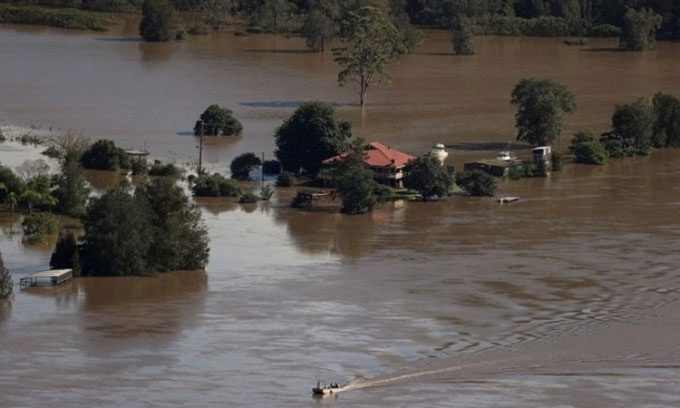
Prolonged rain causing flooding in Australia in 2021. (Photo: Reuters).
The tropics exhibit a circulation pattern known as the Walker Circulation, named after Sir Gilbert Walker, a British physicist from the early 20th century. The Walker Circulation is a massive cycle of rising and descending air in different regions of the tropics. Typically, air rises over the Amazon and Indonesia due to moisture from tropical forests, making the air buoyant, and descends over East Africa and the eastern Pacific. During La Niña, this circulation is intensified, resulting in wetter conditions where the air rises and drier conditions where it descends. In El Niño, ocean temperatures in the eastern Pacific shift this circulation, leading to more storm activity in that region.
El Niño and La Niña also affect the jet stream, a strong air current blowing from west to east across the U.S. and many areas at mid-latitudes. During El Niño, the jet stream tends to push storms towards the subtropics, causing typically dry areas to become wetter. Conversely, mid-latitude storm-prone areas may become drier.
This year, experts predict a rapid transition to La Niña, likely occurring by the end of summer. Following the strong El Niño the world experienced at the end of 2023 and the beginning of 2024, weather conditions typically shift relatively quickly to La Niña. How long this phenomenon will last remains an open question. While El Niño tends to be short-lived, La Niña can persist for two years or even longer.
Temperatures in the tropical Pacific also influence wind shear over large areas of the Atlantic. Wind shear refers to the difference in wind speed at various altitudes or directions. Strong storms in the North Atlantic find it challenging to maintain their structure in high wind shear conditions, as stronger winds aloft push the storm’s column. La Niña creates less wind shear, removing the brakes on storm development. This is bad news for residents in storm-prone areas like Florida. In 2020, during the most recent La Niña, the Atlantic recorded a record 30 tropical storms and 14 major hurricanes, while 2021 saw 21 tropical storms and 7 major hurricanes.
Experts warn that this Atlantic hurricane season could rival that of 2021, largely due to La Niña. The Atlantic tropics are also unusually warm, with sea surface temperatures breaking records for over a year. This warmth will affect the atmosphere, causing more atmospheric movement over the Atlantic and providing energy for storm winds.
Water supply in the southwestern U.S. may stabilize during the first year of La Niña due to rainfall during the past winter. However, the second year will be more challenging. In the third year, severe water shortages could occur. Drier conditions will also ignite a more intense wildfire season in the West, particularly in the fall.
The impacts of El Niño and La Niña are nearly opposite in the Southern Hemisphere. Chile and Argentina often experience drought during La Niña, while the Amazon region sees increased rainfall. Australia faced severe flooding during the most recent La Niña. La Niña also leads to above-average rainfall in India. However, the effects do not occur immediately. For instance, in South Asia, changes often happen several months after La Niña officially appears. La Niña also negatively impacts East Africa, where communities are facing prolonged drought.
El Niño and La Niña occur against the backdrop of a warming world. In the summer of 2023, the world witnessed global temperatures breaking records for ten consecutive months. La Niña may help temper temperatures, but greenhouse gases contributing to global warming continue to rise. While the transition between El Niño and La Niña can cause short-term temperature fluctuations, the overall trend is that the Earth is getting hotter.
