At 4 AM on September 27, Typhoon Noru was located over the southeastern waters of the Paracel Islands, with maximum winds of 166 km/h, equivalent to Category 14, with gusts increasing by two levels.
The National Center for Hydro-Meteorological Forecasting reported that the storm had intensified by more than one level compared to the end of September 26 due to energy gained from the warm, humid sea. Today, the storm is primarily moving westward at a speed of 20-25 km/h and may strengthen further.
The radius of strong winds of level 6, with gusts of level 8 and above, extends about 250 km; the radius of strong winds of level 10, with gusts of level 12 and above, extends about 150 km from the center of the storm.
By 4 PM, the storm’s center was approximately 300 km from Da Nang, 250 km from Quang Nam, and 240 km from Quang Ngai to the east, with maximum winds of 183 km/h, equivalent to Category 14-15, with gusts of level 17.
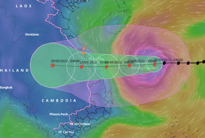
Forecast path and affected area of Typhoon Noru as of 4 AM today. (Photo: General Department of Disaster Prevention)
In the next 12-24 hours, the storm will maintain its speed moving westward. By 4 AM tomorrow, the storm center is expected to be near the coastal areas of Quang Tri – Binh Dinh, with maximum winds of 166 km/h, equivalent to Category 14, with gusts increasing by two levels.
In the following hours, the storm will move deeper inland into Central Vietnam, gradually weakening into a tropical depression, and then a low-pressure area in Thailand.
Thus, compared to the news from Vietnamese media yesterday, today the storm center is forecasted to shift slightly south. Due to the increase in intensity, the direct impact area has expanded to Quang Tri, instead of stopping at Thua Thien Hue. The five provinces within the storm’s center are Quang Tri, Thua Thien Hue, Da Nang, Quang Nam, and Binh Dinh.
International meteorological stations maintain their assessments of the storm’s path and landfall area being the provinces from Thua Thien Hue to Binh Dinh. The Japan Meteorological Agency predicts the storm will make landfall with winds of 162 km/h, while the Hong Kong Observatory estimates it at 185 km/h (super typhoon level).
Almost the entire East Sea is affected by storm winds
The Vietnam Meteorological Service has identified the dangerous area in the East Sea over the next 24 hours (with winds of level 6 and gusts of level 8 and above) from latitude 12.5 to 19.5; west of longitude 116. All vessels operating in the dangerous area are at high risk of being affected by strong winds, large waves, and tornadoes.
The northern and central East Sea (including the waters of the Paracel Islands) will experience stormy weather, with strong winds of levels 8-10, increasing to levels 11-12, and near the storm center reaching levels 14-15, with gusts of level 17; wave heights of 9-11 m.
The southern East Sea (including the waters of the Spratly Islands), the area from Binh Thuan to Ca Mau, and the Gulf of Tonkin will have strong winds of levels 6-7, with gusts of levels 8-9, and wave heights of 3-4 m.
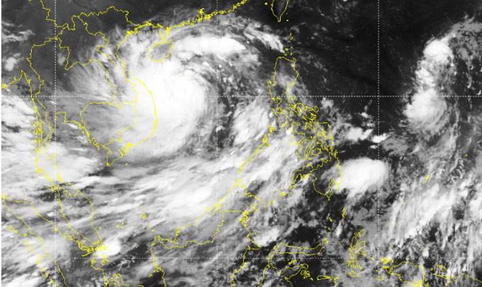
Satellite image of the storm on the morning of September 27. (Source: NCHMF)
Since this morning, offshore from Quang Binh to Ninh Thuan (including Con Co Island, Cu Lao Cham, and Ly Son) has experienced strong winds of levels 8-9, increasing to levels 10-11, with winds near the storm center reaching levels 13-14, with gusts of level 16; wave heights of 8-10 m.
From this afternoon, the coastal waters from Thua Thien Hue to Binh Dinh will experience strong winds of levels 9-10, increasing to levels 11-12, with winds near the storm center reaching levels 13-14, with gusts of level 16; wave heights of 3-5 m, and near the storm center 6-8 m.
The water level from Quang Binh to Quang Ngai due to the storm combined with the tide may rise to 2-2.5 m, causing flooding in low-lying coastal areas and river mouths.
The storm will directly impact the mainland from this evening
From this evening, the coastal areas of Thua Thien Hue, Da Nang, Quang Nam, Quang Ngai, and Binh Dinh will experience strong winds of levels 9-10, with winds near the storm center reaching levels 12-13, and gusts of level 14-15. Further inland, winds will be strong at levels 8-9, with gusts of levels 12-13; Quang Binh, Quang Tri, and Phu Yen will see winds of level 6, increasing to levels 7-8, with gusts of levels 9-10.
From early tomorrow, the two Central Highlands provinces of Kon Tum and Gia Lai will begin to be affected by storm winds increasing from levels 6 to 8, with some places reaching level 9, and gusts of level 11.
Today and tomorrow, Quang Tri, Thua Thien Hue, Da Nang, Quang Nam, Quang Ngai, and Kon Tum are forecasted to receive rainfall of 250-350 mm, with some places exceeding 450 mm. Quang Binh, Binh Dinh, Gia Lai will generally see rainfall of 100-200 mm, with some areas exceeding 300 mm. From tomorrow, heavy rainfall is expected to expand to the North Central region and the southern plain of the Northern Delta.
In response to the storm, at 7 AM today, Prime Minister Pham Minh Chinh chaired an online meeting, with the main venue at the Government Office, connecting with the People’s Committees of the provinces of Quang Tri, Thua Thien Hue, Da Nang, Quang Nam, Quang Ngai, Binh Dinh, Gia Lai, and Kon Tum, and with the People’s Committees of districts and towns at risk of being affected by the storm and landslides.
The Forward Command for Typhoon Noru has also been established in Da Nang. Currently, 8 provinces from Quang Binh to Phu Yen have banned fishing activities, while Khanh Hoa plans to impose a ban starting at 2 PM today. As of 6 PM yesterday, the National Steering Committee for Disaster Prevention reported that 51 vessels and 437 people were still in the dangerous sea areas.
Da Nang, Phu Bai, Pleiku, Phu Cat, and Chu Lai airports will be closed on September 27-28. A few passenger ships on the North-South route and ships to Ly Son Island (Quang Ngai) and Cu Lao Cham (Quang Nam) have suspended operations to ensure safety during the storm.
Nearly two million students from Quang Tri to Phu Yen will have a day off starting today. Da Nang City has allowed civil servants to leave work from 12 PM today and has suspended markets throughout the city to focus on storm response.

A resident applying tape to windows at a building in Da Nang on September 26. (Photo: Nguyen Dong)
Noru is the fourth typhoon to enter the East Sea this year. Experts assess that Noru has a similar pattern to Typhoon Xangsane that struck Da Nang – Quang Nam in September 2006; and Typhoon Ketsana that affected Quang Nam – Quang Ngai at the end of September 2009.
Typhoon Xangsane caused heavy rainfall in the Nghe An – Quang Ngai area, with Quang Binh – Thua Thien Hue receiving 300-400 mm of rain, resulting in 76 deaths and missing persons, 532 injuries, nearly 350,000 houses destroyed or damaged, and nearly 1,000 ships sunk or damaged.
Typhoon Ketsana caused rainfall of 120-270 mm in Quang Binh province, 200-400 mm in Quang Tri, Quang Ngai, Gia Lai, and Kon Tum, and 400-600 mm in provinces from Thua Thien Hue to Quang Ngai. The flooding resulted in 163 fatalities, 11 missing persons, over 21,000 houses collapsed or washed away, and nearly 260,000 other houses severely damaged. The estimated material damage was 14 trillion VND.
- Typhoon Noru with gusts of level 16 creates waves of 9-11m, rapidly moving towards Central Vietnam
- Super Typhoon Noru sweeps through, causing 5 fatalities in the Philippines
- What you need to know about the strongest storm in 20 years about to hit Central Vietnam
- Typhoon Noru with gusts of level 17 approaching the mainland, heavy rain expected in Central Vietnam


