Typhoon No. 1 (internationally named Chaba) is intensifying compared to yesterday and is primarily moving northwest.
The National Center for Hydro-Meteorological Forecasting reported that at 4 AM on July 1, the center of the typhoon was located at approximately 17.8 degrees North latitude and 114.6 degrees East longitude, about 360 km northeast of the Paracel Islands.
The maximum wind speed near the center of the typhoon is at level 10 (89 – 102 km/h), with gusts reaching level 12. The radius of strong winds at level 6, with gusts at level 8, is about 150 km from the center of the typhoon.
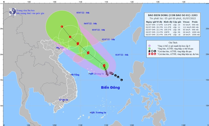
The path of Typhoon No. 1 in the coming hours. (Photo: NCHMF)
Forecast for the next 24 hours: the typhoon is expected to continue moving northwest at approximately 15 km/h and may intensify further. By 4 AM on July 2, the center of the typhoon is forecasted to be at about 20.3 degrees North latitude and 111.5 degrees East longitude, over the waters northeast of Hainan Island (China), about 400 km southeast of Quang Ninh. The maximum wind speed near the center of the typhoon is expected to reach level 10-11 (89-117 km/h), with gusts up to level 13.
Dangerous areas due to the typhoon in the East Sea for the next 24 hours (winds of level 6 or higher, gusts of level 8 or higher): North of latitude 16 degrees North; from longitude 109.0 to 116.5 degrees East. All vessels operating in the dangerous area are at high risk of being affected by strong gusts and large waves.
Disaster risk level: level 3.
In the next 24 to 48 hours, the typhoon will continue moving primarily northwest at a speed of 10-15 km/h. By 4 AM on July 3, the center of the typhoon is forecasted to be at about 22.1 degrees North latitude and 109.5 degrees East longitude, over land in the southeast of Guangxi Province (China), about 170 km northeast of Quang Ninh. The maximum wind speed near the center of the typhoon is expected to be at level 8 (62 – 74 km/h), with gusts up to level 10.
Dangerous areas due to the typhoon in the East Sea for the next 24 – 48 hours (winds of level 6 or higher, gusts of level 8 or higher): North of latitude 18.0 degrees North; from longitude 106.5 to 114.0 degrees East. All vessels operating in the dangerous area are at high risk of being affected by strong gusts and large waves.
In the next 48 to 72 hours, the typhoon is expected to continue moving northwest at about 10 km/h and weaken into a tropical depression. By 4 AM on July 4, the center of the tropical depression is forecasted to be at about 22.1 degrees North latitude and 109.5 degrees East longitude, about 200 km north of Quang Ninh. The maximum wind speed near the center of the tropical depression is expected to be at level 6 (39 – 49 km/h), with gusts up to level 8.
In the next 72 to 96 hours, the tropical depression will continue moving northwest at a speed of 10 – 15 km/h and is expected to gradually weaken.
The National Center for Hydro-Meteorological Forecasting warns that due to the influence of the circulation of Typhoon Chaba, the North East Sea (including the waters of the Paracel Islands) will experience strong winds of levels 8-9, with near center winds of levels 10-11, gusts reaching level 13; wave heights from 5.0 – 7.0 meters, with rough seas.
The coastal areas of provinces from Quang Ninh to Ninh Binh need to be vigilant for large waves combined with high tides causing flooding in low-lying areas.
In the waters from Binh Thuan to Ca Mau, the Central and Southern East Sea (including the waters of the Spratly Islands) will experience southwest winds of level 6, occasionally level 7, with gusts of level 8 – 9, wave heights from 2.0 – 4.0 meters, with rough seas.
