The extensive circulation of Typhoon No. 3 is starting to bring heavy rain to many areas in Northern Vietnam, and the rain is expected to continue with increasing intensity from this afternoon (August 25).
Typhoon Brings Heavy Rain to Northern Vietnam
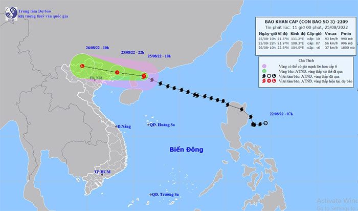
According to the National Center for Hydro-Meteorological Forecasting, as of 10 AM today (August 25), Typhoon No. 3, Maon, was located over the coastal area of southern Guangdong Province (China), approximately 350 km east of Mong Cai (Quang Ninh). The strongest winds near the center of the typhoon reached level 10 (89-102 km/h), with gusts up to level 13. The radius of strong winds at level 6 and gusts at level 8 extends about 150 km from the typhoon’s center.
Forecast for the next 12 hours: the typhoon is mainly moving westward at a speed of about 25-30 km/h and is gradually weakening into a tropical depression.

Position and next movement direction of Typhoon No. 3 Maon. (Photo: National Hydro-Meteorological Forecasting Center).
By 10 PM tonight, the center of the tropical depression is expected to be over the border area between Vietnam and China, about 50 km northeast of Mong Cai (Quang Ninh). The strongest winds near the center of the tropical depression will be at level 7 (50-61 km/h), with gusts up to level 9.
Forecast for the next 12 to 24 hours: the tropical depression will move in a west-northwest direction at a speed of about 30 km/h and will gradually weaken into a low-pressure area over the northern mountainous region. The maximum wind speed at the center of the low-pressure area will decrease to below level 6 (under 39 km/h).
Due to the influence of the typhoon, the western sea area of the northern East Sea will experience storms, with strong winds of level 8-9 and gusts of level 11; wave heights will be from 4-6 meters; the sea will be very rough.
In the northern Gulf of Tonkin (including the islands of Bach Long Vi and Co To), winds are increasing to levels 6-7, near the typhoon’s center reaching level 8, with gusts up to level 10, and wave heights from 2.5-3.5 meters. The sea will be rough.
On land, from the afternoon of August 25 to the morning of August 26, the coastal areas of Quang Ninh may experience strong winds at level 6, with gusts up to level 8; in Hai Phong and Lang Son, gusts may reach levels 6-7.
From today (August 25) to the night of August 26, heavy to very heavy rain and thunderstorms with strong gusts are expected in the northern region, with total rainfall accumulation generally between 100-200 mm, with some areas exceeding 250 mm; Thanh Hoa is expected to receive 50-100 mm, with some areas exceeding 150 mm.
There is a risk of flash floods in small rivers and streams, landslides on slopes, and localized flooding in residential areas and low-lying regions in the northern mountainous provinces and Thanh Hoa.
Proactive Measures to Ban Sea Activities Based on Actual Conditions
To proactively respond to the typhoon and strong winds, the Standing Office of the National Steering Committee for Disaster Prevention and Control recommends that provinces and cities in the forecast area regularly monitor updates on the typhoon’s developments and strong winds, and promptly inform all levels of government and the public.
For the provinces of Quang Ninh and Hai Phong: Strictly manage fishing vessels going out to sea, continue to review and notify, call for, and guide vessels still operating in the typhoon-affected areas to move out of dangerous areas or seek shelter; ensure the safety of people and property on fish farming rafts and shelters.
Implement measures to ensure safety for people and property, especially tourism activities on islands and coastal areas. Ensure safety for traffic participants on sea bridges, and proactively ban sea activities based on actual local conditions.
Direct safety measures for coastal dikes and river mouth dikes, especially at vulnerable positions or under construction. Implement safety measures for infrastructure, ports, economic zones, industrial zones, factories, warehouses, mines, and coastal projects under construction.
Be ready with drainage measures to prevent flooding in urban areas and drainage to protect agricultural production. Deploy rapid response teams to check and review high-risk areas, and assist residents in evacuating to safe locations.
For Lang Son Province: Closely monitor and provide timely guidance to proactively prevent strong gusts; organize tree trimming; secure and reinforce signage, housing, public works, industrial zones, factories, warehouses, and tall structures.


