A seismologist at the University of Melbourne estimates that the energy released by the earthquake in Turkey on February 6 is enough to power New York City for over four days.
The earthquake struck the densely populated southeastern region of Turkey at 4:17 AM local time (8:17 AM Hanoi time), according to the United States Geological Survey (USGS), measuring 7.8 on the Richter scale.

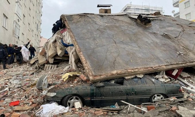
Residents searching through the rubble in Diyarbakir, Turkey. (Photo: Reuters).
Januka Attanayake, a seismologist at the University of Melbourne, Australia, shared that the energy released by this earthquake is equivalent to about 32 petajoules, enough to sustain New York City for over four days. In terms of energy, a 7.8 magnitude earthquake releases approximately 708 times more energy than a 5.9 magnitude earthquake, Attanayake stated.
The strength of an earthquake is measured on the local intensity scale. An earlier version was known as the Richter scale. This scale is logarithmic, meaning that for each unit increase, the energy released by the earthquake increases by about 32 times.
However, the potential damage from an earthquake depends on many factors, not just its magnitude. Among these, the population density of the area and the depth of the epicenter contribute to the level of damage. For instance, shallow earthquakes are more likely to cause significant damage. The epicenter of the first earthquake in Turkey on February 6 was located at a depth of 17.9 kilometers.
Another important factor is the quality of construction in the area. “Residents in the region live in extremely vulnerable structures to shaking, although there are some resilient buildings. The types of housing most affected are brick homes without steel reinforcement and low-rise concrete structures that are not easily ductile,” the USGS noted.
In a report issued about 30 minutes after the earthquake, experts at the USGS calculated a 34% chance of fatalities between 100 and 1,000 people and a 31% chance of fatalities between 1,000 and 10,000 people. Over 1,200 fatalities have already been reported following the initial earthquake, with casualty numbers continuing to rise. The report estimates the economic damage from the earthquake to be equivalent to 1% of Turkey’s gross domestic product, according to the New York Times.
In a Twitter post, seismologist Susan Hough at USGS wrote that although it is not the strongest earthquake the world has recorded in recent decades, the earthquake in Turkey is particularly dangerous due to its location and shallow depth of the epicenter. At the lowest end of the scale, a magnitude 1 earthquake is a microquake that humans cannot feel. Meanwhile, a magnitude 7 is described by geologists as having “energy equivalent to about 32 Hiroshima atomic bombs,” according to Renato Solidum, director of the Philippine Institute of Volcanology and Seismology.
At a magnitude of 7.8, the earthquake in Turkey is classified as an “extreme earthquake.” Similar magnitude earthquakes include the 2013 earthquake in Pakistan that killed about 825 people and the April 2015 earthquake in Nepal, which claimed nearly 9,000 lives. According to Dr. Attanayake, this event appears to be part of a series of earthquakes. A fault line stretching approximately 1,500 kilometers separates the Eurasian tectonic plate to the north from the Anatolian tectonic plate to the south, producing numerous tremors of magnitude 6.7 or higher since 1939.
About 98% of Turkey’s territory is prone to earthquakes and approximately one-third of the country is at high risk, including areas surrounding major cities such as Istanbul and Izmir, as well as Eastern Anatolia.
The reason lies in the fact that much of the country is situated on the Anatolian tectonic plate, located between two large tectonic plates, the Eurasian and African plates, and the smaller Arabian plate. As the larger African plate and the Arabian plate move, Turkey is compressed, while the Eurasian plate prevents any movement of Turkey to the north. Consequently, Turkey lies on several fault lines.
The North Anatolian Fault, where the Anatolian and Eurasian tectonic plates intersect, is considered to be the most destructive fault line, stretching from southern Istanbul to northeastern Turkey.


