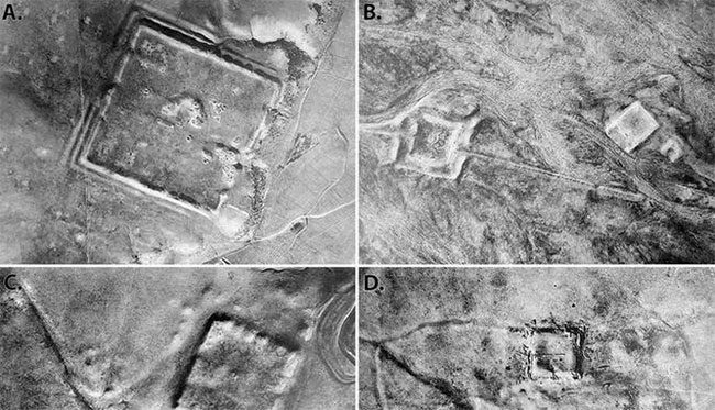
Recently declassified Cold War satellite images have revealed hundreds of previously unknown Roman fortifications, challenging historians’ understanding of this ancient empire.
Archaeologists examined aerial photographs taken during the 1960s and 1970s, which disclosed 396 Roman fort sites in Syria and Iraq, throughout the Syrian steppe (also known as the Syrian desert or Badiya), according to The Guardian.
The findings, published on October 26 in Antiquity, an international journal specializing in archaeology, compel researchers to reevaluate life at the edge of the ancient Roman Empire.

A “ghost fortress” recently discovered among a cluster of 400 structures spanning present-day Iraq and Syria. (Photo: ANTIQUITY).
French Jesuit explorer Antoine Poidebard, a pioneer of aerial archaeology in the Middle East, conducted surveys in the area in 1934. During that survey, he recorded a chain of 116 fortresses.
Historically, scholars have believed these fortifications were part of a defensive line constructed to protect the eastern province of the Roman Empire from invasions by Arabs and Persians, as well as from nomadic tribes intent on capturing and enslaving.
However, the authors of the newly published study indicate that this new discovery suggests the borders of the Roman Empire were not as rigid as previously thought and served as a vibrant site of trade rather than a constant battlefield. The 396 fortresses, spread from east to west, may have supported a system of trade, communication, and military transport across regions based on caravan routes.
“Since the 1930s, historians and archaeologists have debated the strategic or political purpose of this fortification system. Yet very few scholars have questioned Poidebard’s fundamental observation that there is a chain of fortifications defining the eastern border of Rome,” said the lead author of the study, Professor Jesse Casana from Dartmouth College (New Hampshire, USA).
Researchers believe that ancient Rome was a militaristic society, yet it clearly valued trade and communication with areas not directly under its control.
The images studied were part of the world’s first satellite reconnaissance program, launched during a time of heightened geopolitical tension between the United States and the Soviet Union during the Cold War. Utilizing these images, archaeologists uncovered fortresses previously obscured by modern developments.
“Careful analysis of this crucial data could lead to future discoveries in the Middle East and beyond,” Professor Casana stated.


