Forecast: Hurricane Helene Continues to Strengthen, Transforming into a Giant “Monster” Storm as It Moves Northward.
Where is Hurricane Helene Heading?
According to the U.S. National Hurricane Center (NHC), it is rare for a tropical depression to be predicted to become a major hurricane within 60 hours. The entire forecast has essentially been faster than any predictions made in the previous 36 and 48 hours for a tropical depression.
Commenting on this storm, John Cangialosi, a senior hurricane specialist at the NHC, predicts that the winds of Hurricane Helene “will increase by 70 nautical miles in 72 hours by September 23, which is one of the fastest forecasts ever” for a potential tropical storm.
“There is reason for such a forecast. We are trying to anticipate the possibility of rapid intensification of the storm before it reaches Florida,” Cangialosi shared.

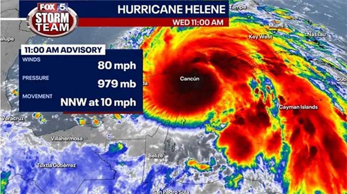
Sharp image of Hurricane Helene’s eye. (Photo: NOAA).
Among the computer models used to forecast the storm, some indicate that Hurricane Helene will continue to strengthen and may drop the central pressure to the lowest recorded level in the Gulf of Mexico. Additionally, some other models even forecast that Hurricane Helene could make landfall at Category 4 or Category 5 intensity.
Labor Newspaper cites CNN, thousands of people are being forced to evacuate in Florida as Helene is expected to be the strongest hurricane to hit the U.S. in over a year.
Flood warnings have been issued for over 20 million people from Florida to southern Appalachians. The Big Bend area is facing the most severe storm surge, potentially reaching 4.5 meters.
Before Hurricane Helene arrived, the Big Bend area of Florida was still recovering from several recent storms. Hurricane Debby made landfall in this area in early August as a Category 1 storm, and recovery efforts are still ongoing.
Hurricane Helene is Intensifying at a Rate Described as “Unprecedented in History”
Hurricane Helene rapidly intensified into a hurricane on September 25 and is forecast to continue strengthening daily as it moves over record warm waters in the Gulf of Mexico, according to the latest storm updates from the NHC.
By the afternoon of September 26, Hurricane Helene’s wind speeds reached at least 210 km/h. Hurricane forecasters at the NHC do not rule out the possibility of Helene intensifying further in the hours leading up to landfall.
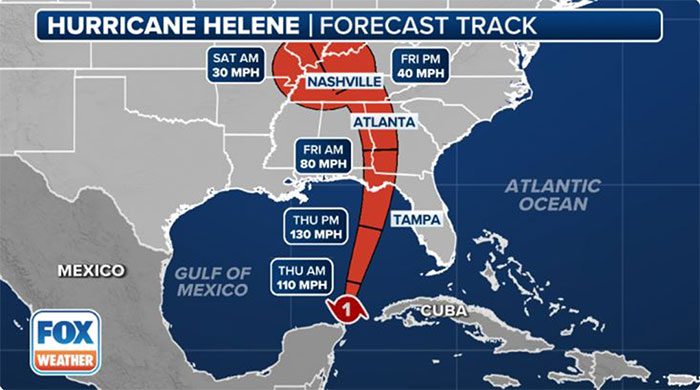
Notably, the eye of the storm – where the most dangerous winds are located – is expected to make landfall around Apalachicola, Florida, USA on the evening of September 26.
However, the terrifying eye of the storm is just one part of the impact of this latest storm in the Atlantic hurricane season, the latest CNN storm report notes.

Forecast path of Hurricane Helene. (Photo: Fox Weather).
The forecast indicates that Hurricane Helene will continue to strengthen, transforming into a giant “monster” storm as it moves northward. The hurricane is poised to strike not only Florida but also a large portion of the southeastern U.S.
In light of the unpredictable developments of Hurricane Helene, thousands of Florida residents have been forced to evacuate, and almost the entire state is on high alert as Helene threatens to bring heavy rainfall, strong winds, and life-threatening flooding.
Initial damage reports from Hurricane Helene indicated its first impacts in some areas of the Yucatán Peninsula, Mexico, and Cuba on September 25. Heavy rains submerged many cars in Quintana Roo, Mexico. Strong winds from Hurricane Helene caused power outages for over 50,000 people in Pinar del Río province, western Cuba.
Weather forecasts for areas in the projected path of Hurricane Helene may face even worse impacts.
According to meteorologists, Helene is expected to be the 4th hurricane to make landfall in the U.S. this year and the 5th hurricane to strike Florida since 2022. However, the latest storm, Helene, will be different from Hurricane Idalia and other storms that have impacted the state.
Remarkably, Helene is forecast to become one of the largest storms in the Gulf of Mexico in the past century, according to hurricane expert Michael Lowry.
Specifically, the wind field of Hurricane Helene could be large enough to stretch from Washington D.C. to Indianapolis. This means there will be larger waves and broader impacts, even when the storm’s eye is far from the coastline.
“Hurricane Helene will not resemble any storm we have encountered so far,” warned the Taylor County Sheriff’s Office in Florida.
The scale of the “monster” nature of Hurricane Helene also increases the risk of life-threatening storm surges when the hurricane makes landfall in the U.S. on the evening of September 26.
Tropical storm warnings extend hundreds of kilometers from South Florida to Tennessee and southern South Carolina due to the scale of Hurricane Helene.
To minimize damage from the storm’s impact, the Governor of South Carolina declared a state of emergency on September 25. Florida, Georgia, and North Carolina have also declared statewide emergencies due to the latest hurricane.
U.S. hurricane forecasters note that hurricanes often weaken quickly as they move deeper inland due to the loss of warm ocean water fueling them, but Helene is expected to maintain its strength even deep inland due to its rapid motion and intensity at landfall.
As a result of Hurricane Helene, over 600 flights were canceled on September 26, according to FlightAware.
|
Weather forecasts for the October-December period indicate that storms and tropical depressions will be active in the South China Sea and will impact Vietnam approximately at or above the long-term average (the long-term average is 4-5 storms in the South China Sea, of which 2-3 will impact Vietnam). The winter monsoon is likely to arrive later than the long-term average; it will be weaker in November and December and stronger in January-March 2025. |


