Images from satellites reveal the scale of the disaster caused by a massive wildfire that devastated the town of Lahaina on the island of Maui, Hawaii, resulting in dozens of fatalities.
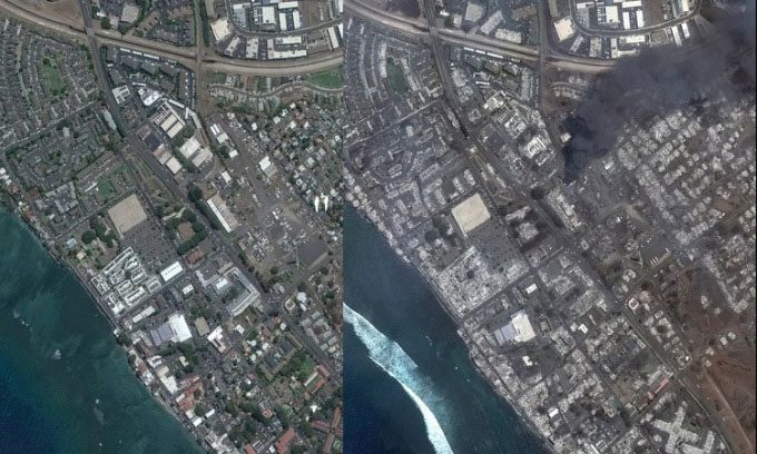
Lahaina town before the wildfire disaster. (Photo: Maxar Technologies).
Uncontrolled wildfires erupt in drought-stricken Maui earlier this week, threatening the town of Lahaina in Hawaii. Satellites provided aerial images of the disaster. The inferno engulfing the historic town on the second largest island in Hawaii began on August 8 under unclear circumstances, according to Space. The fire rapidly escalated to a massive scale shortly thereafter, partly due to strong winds generated by Hurricane Dora passing through the area. At least 68 people have died, and thousands have lost their homes.
Meteorologists explain that although Hurricane Dora was over 1,200 kilometers south of the Hawaiian Islands, its interaction with a high-pressure system to the north of the Pacific created strong winds that accelerated the fire’s spread across Maui’s dry terrain.

Lahaina town devastated by the flames. (Photo: Planet).
Images provided by two American Earth observation companies, Maxar Technologies and Planet, compare Lahaina and its surroundings before and after the fire. While a June photo from Maxar shows the neighborhood lush with greenery, an image from September 9 reveals a landscape covered in brown and gray ash with thick, dark smoke rising ominously. Planet’s image taken a day later depicts a similar scene after the smoke cleared.
NASA’s Landsat 8 satellite also captured images of the burning town on August 8, shortly after the initial reports of the fire. In that photo, nearly the entire town, which had a population of about 12,000 before the disaster, is ablaze with orange flames. The European Earth observation satellite Sentinel-2 also recorded the area engulfed in flames as it passed overhead on August 8. The intensity of the fire in Hawaii was so severe that it was clearly visible in images taken by weather satellites in geostationary orbit 36,000 kilometers above the Earth.
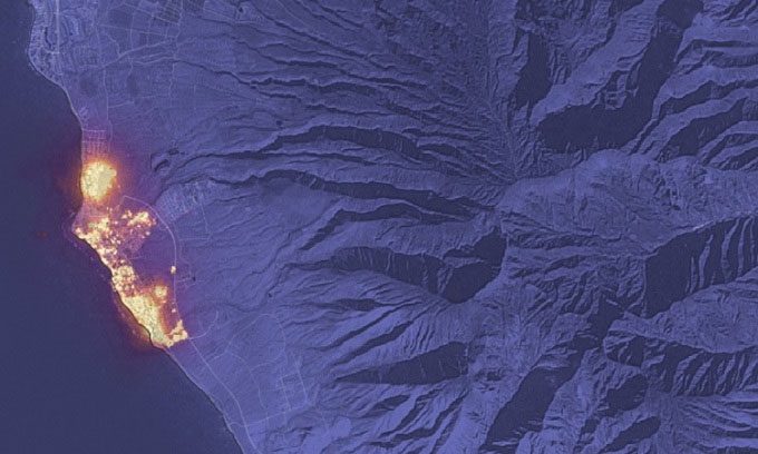
Wildfire in Lahaina captured by Sentinel-2 satellite. (Photo: NASA).
The fire continued to rage on the island of Maui as of August 11. Hawaii’s Governor, Josh Green, stated that this fire is “the largest natural disaster in Hawaii’s history” and that 80% of Lahaina has been destroyed. According to the National Weather Service, the winds fueling the fire have weakened, maintaining a moderate level over the weekend and into the following week.
According to CBS News, National Guard helicopters involved in firefighting operations had to land due to wind gusts exceeding 97 kilometers per hour sweeping across the island. In fact, the strong winds alone were enough to wreak havoc on the area, toppling power lines and destroying homes. Relief and humanitarian efforts have been further complicated by Maui’s remote location and limited resources to address such a large-scale disaster.


