A heavy rainfall, significantly exceeding the average for September each year, is currently pouring down on the Sahara Desert, one of the driest regions on Earth.
Scientists are unclear why this desert is experiencing such extensive rainfall, but the reason may be linked to the unusually calm Atlantic hurricane season. The rain has been so heavy that some arid regions in North Africa are now experiencing monsoon-like conditions and flooding, with some areas in the Sahara predicted to receive five times the average September rainfall, as reported by Live Science on September 13.
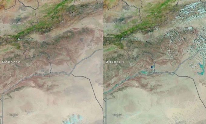
Satellite images of the Sahara Desert before (August 22, 2024, left) and after (September 10, 2024, right) the rainfall. (Image: NASA).
Rainfall in the Sahara is not entirely uncommon. The vast and diverse area includes regions that typically receive light precipitation, according to Moshe Armon, an atmospheric scientist at the Swiss Federal Institute of Technology (ETH) in Zurich. However, currently, many areas of the Sahara are flooding, including regions further north that are usually drier. Some scientists suggest this is part of Earth’s natural climate variability, while others argue it results from human-induced climate change. “The answer may lie somewhere in between,” Armon stated.
Climate change in the Sahara could be related to a weaker Atlantic hurricane season. So far, the 2024 hurricane season has been relatively quiet, despite predictions of strong storm activity earlier in the summer due to elevated ocean temperatures. Meteorologists emphasize that for the first time in 27 years, no hurricanes formed in the Atlantic on the first day of September. More than half of the named storms and 80-85% of major hurricanes in the Atlantic each year typically originate from the region south of the Sahara, according to Jason Dunion, a meteorologist at the National Oceanic and Atmospheric Administration (NOAA).
In a typical hurricane season, atmospheric waves move away from the coastal region of West Africa into the North Atlantic, along the Intertropical Convergence Zone (ITCZ), a belt near the equator where air from the Northern Hemisphere meets that of the Southern Hemisphere. The ITCZ can carry clouds, rain, and storms. Atmospheric waves move westward along the ITCZ over the Atlantic, combining with warm sea water to develop into tropical storms.
However, part of the ITCZ has shifted northward this year, crossing through the northern Sahara. Scientists do not fully understand why this is occurring, although previous climate models predicted that the ITCZ would shift northward due to rising ocean and air temperatures, as carbon emissions cause the Northern Hemisphere to warm faster than the Southern Hemisphere.
The impact of this northward shift is that the ITCZ is pushing rain further into North Africa than usual, across the Sahara Desert, while the typical path of atmospheric waves from North Africa is also disrupted. Without the moisture from the warming ITCZ over the Atlantic, there are insufficient factors for strong storms to develop. However, the peak of the Atlantic hurricane season typically falls in mid-September, so this quiet period does not mean that a dangerous strong hurricane cannot occur.
Meanwhile, the unusual high rainfall in the Sahara may result from warmer than usual sea temperatures in the North Atlantic and the Mediterranean. The Sahara Desert may continue to experience wetter conditions in the future. Human activity, particularly greenhouse gases, is driving the oceans to absorb more heat. Some climate models predict that warmer oceans will push monsoon rains further north in Africa by 2100, meaning that arid regions may experience more rainfall.
