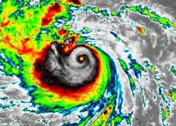
The National Center for Hydro-Meteorological Forecasting reported that Typhoon Doksuri is currently active in the eastern waters of the Philippines, maintaining its strongest winds at levels 14-15, with gusts exceeding level 17 in recent hours.
On July 25, the typhoon is moving northwest at a speed of 15 km/h and has the potential to strengthen. By this afternoon, it is expected to develop into a super typhoon, with wind speeds near the center reaching level 16 and gusts exceeding level 17.
After this time, the typhoon will maintain its course, slow down, and maintain intensity until it enters the eastern waters of the North China Sea on July 26.
The forecast trajectory map indicates that after entering the South China Sea, the super typhoon will primarily move northwest, with intensity decreasing to level 14. On July 28, this system is likely to make landfall in Fujian Province (China).
The meteorological agency assesses that Typhoon Doksuri poses a low risk of affecting the weather on land in our country and mainly impacts the sea.
From July 25, the eastern waters of the North China Sea will experience increasing winds of level 6-7, later rising to levels 7-8. The area near the center of the typhoon will have winds of levels 10-11, with gusts reaching level 14. Waves will be 5-7 meters high, creating very rough seas.
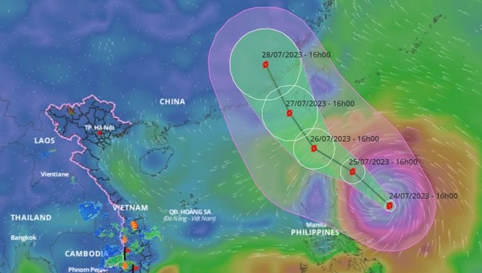
Forecast path of Typhoon Doksuri likely to develop into a super typhoon today (July 25) before entering the South China Sea. (Photo: VNDMS).
On land, thunderstorms will persist in the Central Highlands and the South today. Rainfall is expected to be between 20-50 mm/day, with some areas exceeding 70 mm, particularly in the afternoon and evening. Residents are advised to be cautious of the risk of urban flooding and inundation in low-lying areas when heavy rains fall in a short time.
Additionally, the area from Thừa Thiên-Huế to Bình Thuận is also expected to see rainfall between 20-40 mm today. Heavy rain in these areas is likely to continue for the next 2-3 days.
Meanwhile, the North and Thanh Hóa will continue to experience heat waves, with maximum temperatures reaching 35-37 degrees Celsius, and some areas exceeding 37 degrees Celsius.
On July 26, the heat will extend to the North Central region, followed by the Central Coast. Temperatures in some areas may rapidly exceed 37 degrees Celsius, with humidity dropping to 50-60%, leading to a dry, hot sensation.
|
On July 15, Typhoon Talim formed in the South China Sea from a tropical depression, marking the first storm to operate in the area this year. Doksuri is likely to be the second storm. The meteorological agency forecasts that from now until August 20, the South China Sea may experience 1-2 storms or tropical depressions. Given the potential impact of Typhoon Doksuri on maritime weather, the Standing Office of the National Steering Committee for Disaster Prevention has advised relevant authorities in coastal provinces and cities from Quảng Ninh to Khánh Hòa to closely monitor the storm’s developments. Local authorities need to review and notify vessels operating at sea to proactively avoid danger zones, and to prepare rescue forces and equipment for emergency situations. |
