Due to the impact of Typhoon Trammi, from the evening of October 26 to October 28, many areas will experience heavy to very heavy rainfall.
This morning (October 25), the Department of Dyke Management and Natural Disaster Prevention (Ministry of Agriculture and Rural Development) held a meeting to respond to Typhoon Trammi.
At the meeting, Mr. Nguyen Van Huong, Head of the Weather Forecasting Department (National Center for Hydro-Meteorological Forecasting) stated that yesterday afternoon, Typhoon Trammi entered the eastern sea area of the Northern East Sea, becoming the sixth typhoon of 2024. Before moving into the East Sea, the typhoon changed direction four times.
In addition, there is currently a tropical depression forming offshore to the east of the Philippines, which is expected to strengthen into a typhoon within the next 24-48 hours and move towards the northeastern part of Luzon, causing Typhoon Trammi to interact with another storm and weaken.
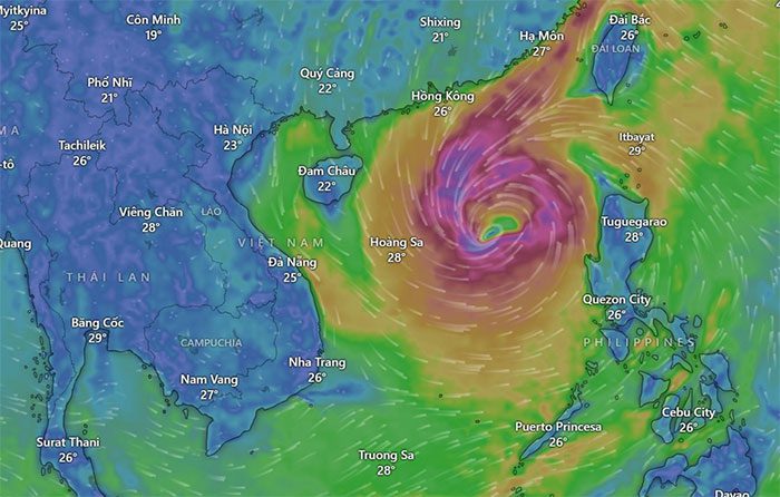
The circulation of Typhoon Trammi is relatively wide, with convective clouds shifting westward, leading to strong winds affecting the northern and central parts of the East Sea.
With the current forecasted path of the typhoon, around the afternoon of October 26, the Central Coast may experience strong winds of levels 6-7, increasing to levels 8-9 as the storm approaches.
According to preliminary calculations, from the evening and night of tomorrow (October 26) until October 29, Typhoon Trammi is expected to cause heavy rainfall in the Central region (from Ha Tinh to Binh Dinh, Phu Yen), with heavy rain concentrated in Quang Tri to Quang Nam, Kon Tum, and Gia Lai. There is a possibility of some areas experiencing very intense rainfall, Mr. Nguyen Van Huong reported.

Typhoon Trammi from satellite image (Source: Windy).
Commenting on the intensity of Typhoon Trammi, Mr. Hoang Phuc Lam, Deputy Director of the National Center for Hydro-Meteorological Forecasting stated, within the next 24-48 hours, Typhoon Trammi will move relatively steadily and will strengthen.
“We predict that the maximum intensity will be when the typhoon is over the eastern area of the Paracel Islands, potentially reaching levels 11-12, with gusts of levels 13-14”, Mr. Lam said.
As it reaches the Paracel Islands, the typhoon is expected to slow down and gradually weaken. A cold air mass moving down from the North will contribute to the weakening of the storm, pushing it southward. Subsequently, the typhoon may weaken to levels 7-8 and move out to sea, maintaining its presence for a relatively long time. This pattern is likely to lead to prolonged rainfall in the Central region.
Due to the influence of Typhoon Trammi, from the evening of October 26 to October 28, heavy to very heavy rain is expected in the area from Quang Tri to Quang Ngai, with total rainfall commonly reaching 300-500mm, and locally over 700mm.
The areas of Ha Tinh – Quang Binh, Binh Dinh, and Northern Central Highlands will also experience heavy rainfall, with local areas possibly seeing very heavy rain, with total rainfall common between 100-200mm, and some places exceeding 300mm.


