At 4 AM on August 10, Typhoon Mulan was located approximately 160 km from Hainan Island (China), with maximum wind speeds of 74 km/h. The typhoon is expected to enter the Gulf of Tonkin tonight, bringing rain for three days.
The National Center for Hydro-Meteorological Forecasting reported that today, the typhoon is moving northwest at a speed of 15-20 km/h, expected to reach the Leizhou Peninsula (China) around 5-6 PM, and then enter the Gulf of Tonkin two hours later.
Afterward, the typhoon will shift more to the west. By 4 AM tomorrow, it will be over the northern waters of the Gulf of Tonkin, about 80 km from Mong Cai (Quang Ninh), with maximum wind speeds of level 8, gusting up to two levels higher. As it approaches the mainland, the typhoon will weaken into a tropical depression and then into a low-pressure area over the northern mountainous region of Northern Vietnam.
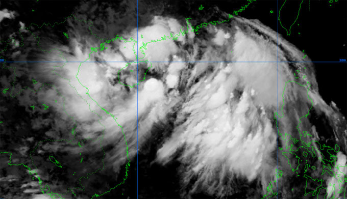
Satellite image of Typhoon Mulan at 7 AM on August 10. (Photo: NCHMF)
The Japan Meteorological Agency forecasts that Typhoon Mulan will pass between the Leizhou Peninsula and Hainan Island of China with wind speeds of about 65 km/h, before moving towards Quang Ninh. The Hong Kong Observatory predicts that the typhoon will enter the middle of Leizhou Island before reaching the Gulf of Tonkin with stronger winds, around 85 km/h.
The meteorological agency warns that the dangerous sea area in the next 24 hours (winds of level 6, gusts of level 8 and above) will be from north of latitude 17.5; from longitude 106.5 to 113.5. All vessels operating in the dangerous area are at risk of strong gusts and high waves.
Today, the northern East Sea will experience increasing winds from level 6 to 8, with gusts reaching level 10, and waves rising to 4-6 meters. The Gulf of Tonkin, including Co To and Bach Long Vi Islands, will see winds increasing to level 8 tonight, with gusts rising two levels, and waves reaching 2-4 meters.
Tonight and tomorrow, the coastal areas of Quang Ninh – Hai Phong will experience strong winds of levels 6-7, with gusts of level 9. Northern Vietnam and the two provinces of Thanh Hoa and Nghe An will see rain from tonight until August 12, with totals ranging from 100-200 mm, and some areas exceeding 250 mm.

Forecast of the path and impact area of Typhoon Mulan on the morning of August 10. (Photo: NCHMF)
The National Steering Committee for Disaster Prevention has requested coastal provinces from Quang Ninh to Khanh Hoa to monitor the typhoon’s developments, count vessels, and implement safety measures for people and property concerning transport and tourism activities.
Mulan formed from a low-pressure area, later developing into a tropical depression and lingering near the Paracel Islands of Vietnam. By the afternoon of August 9, the tropical depression intensified into a typhoon, marking the second typhoon in the East Sea this year.
This year, it is forecasted that there will be 10-12 typhoons and tropical depressions in the East Sea, of which 4-6 will directly affect the mainland of Vietnam.
