 From November 1 to 4, several scientific organizations in Ho Chi Minh City participated in the 16th Workshop on Ocean Models and Information Systems in the Asia-Pacific region. The focus was on the potential deployment of the FORMOSAT-2 satellite imagery data technology project in the coastal areas of Southern Vietnam, spanning from 2006 to 2008.
The project aims to implement the application of FORMOSAT-2 satellite imagery data technology for assessing coastal pollution caused by oil spills and land-based contaminants.
Additionally, the project will assist in the planning and management of mangrove forests and ecotourism, modeling wave-current dynamics and the spread of coastal pollution, monitoring marine meteorology and hydrology, and supervising coastal disasters, particularly the issue of coastal erosion. This will contribute to enhancing the quality of related subjects in higher education training.
The implementation area for the application is the coastal region of Southern Vietnam, including Can Gio in Ho Chi Minh City and surrounding areas where the FORMOSAT-2 satellite can provide data.
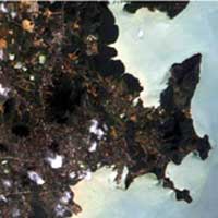 |
FORMOSAT-2 captured images of Phuket Island, Thailand, on December 29, 2004, after being devastated by the Sumatra tsunami. |
The images of the Southern coastal region will be provided daily by FORMOSAT-2, featuring a high resolution of 2 meters for black-and-white images or 8 meters for color images, with a 24 km swath width. This is commercial satellite imagery, priced at $1 per square kilometer.
The implementation of satellite data applications for this project is a pressing necessity for the coastal realities of Southern Vietnam, especially for Ho Chi Minh City and the Can Gio area. This region serves as both a national mangrove ecological forest and an ecotourism area. Furthermore, this area is affected by pollution due to industrialization and urbanization processes from the cities surrounding the Saigon-Dong Nai river basin, and is also polluted by oil spills from vessels entering and leaving the ports in the basin. Access to satellite data, such as that from FORMOSAT-2, provides a favorable condition for researching the aforementioned issues.
With the desire to apply satellite data to address specific issues in the coastal areas of Southern Vietnam, many research institutions in the southern branch of the Vietnam Academy of Science and Technology, such as the Institute of Physics, the Institute of Geography, the Institute of Information Technology, and the Tropical Biology Institute, are undertaking the necessary procedures to directly participate in this project.
At the International Conference on “Using Space Technology in Disaster Monitoring,” organized by the United Nations Office for Outer Space Affairs (UNOOSA) from October 18 to 22, 2004, in Munich, over 70 reports from 50 countries worldwide acknowledged that the application of satellite technology is one of the essential needs in meteorological forecasting, disaster monitoring and prevention, environmental monitoring, resource planning, and more.
However, due to the high costs of investing in satellite data with resolutions below a few meters, developing countries at the Munich Conference requested to share resources from developed countries to use at affordable costs. In response to this need, the APEC Secretariat has approved a project to support the provision of FORMOSAT-2 satellite imagery data for member economies in need.


