Typhoon Yagi has strengthened to category 15 with maximum winds of 183 km/h, a rise of 3 categories since yesterday, and it may reach category 16 (super typhoon) today.
The National Center for Hydro-Meteorological Forecasting reported that at 4 AM today, the center of Typhoon Yagi was located over the northern part of the North East Sea, approximately 550 km from Hainan Island (China). The storm is moving westward, then slightly northward, at a speed of 10 km/h. By 4 AM tomorrow, it will be about 210 km from Hainan Island, with winds of 184-201 km/h, qualifying as a super typhoon.
Afterward, the super typhoon is expected to accelerate to 10-15 km/h, passing close to the Leizhou Peninsula (China) and entering the Gulf of Tonkin on the night of September 6 to the dawn of September 7. At this time, the wind speed is anticipated to drop to categories 13-14, which is within the range of 134-166 km/h, with gusts reaching category 17.
Maintaining its direction and speed of 10-15 km/h, the typhoon will then make landfall in the Quang Ninh – Hai Phong area and move deeper into the northern region, including Hanoi.
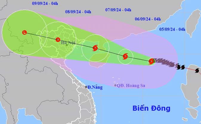
Forecast path and impact area of Typhoon Yagi, morning of September 5. (Photo: NCHMF).
The Japan Meteorological Agency has reported that the storm’s winds are currently at 180 km/h, and will reach a peak of 198 km/h this afternoon. The Hong Kong Observatory assesses Yagi as a super typhoon with wind speeds of 205 km/h, which will increase to 210 km/h this afternoon. The U.S. Navy’s forecast suggests that the storm will reach wind speeds of 205 km/h this afternoon before passing over the Leizhou Peninsula.
Regarding its trajectory, international agencies agree that the storm is veering north toward the Leizhou Peninsula instead of navigating between this peninsula and Hainan Island as previously predicted. This means the storm will encounter more friction with land.
Mr. Hoang Phuc Lam, Deputy Director of the National Center for Hydro-Meteorological Forecasting, noted that the danger posed by Typhoon Yagi is significant as the storm’s center has not yet reached land, but when it is 400-500 km away from Vietnam, the northern region could start experiencing thunderstorms and lightning.
It is likely that on the night of September 6, the storm will enter the Gulf of Tonkin, leading to strong winds and significant rainfall along the coast and inland starting from dawn on September 7. The peak impact is expected from the afternoon of September 7 to the morning of September 8, when heavy rain and very strong winds will be experienced inland.
Due to the storm’s intensity, the affected areas will include northern Vietnam and northern central Vietnam. Notably, the areas most impacted by strong winds and heavy rain will be the coastal provinces of Quang Ninh and Ninh Binh.

Border guards on Bach Long Vi Island, Hai Phong, assist residents in securing boats against Typhoon Yagi, September 4. (Photo: Le Tan).
In the next 24 hours, the northern part of the East Sea will experience strong winds of categories 11-13, with wave heights of 7-9 meters; areas near the storm center will see winds of categories 14-16, with gusts exceeding category 17, and waves reaching heights of 10-12 meters. Starting from the night of September 6, the Gulf of Tonkin will experience winds of categories 10-12, while areas near the storm center will have winds of categories 13-14, with gusts reaching category 17.
On land, from around the night of September 6 to the morning of September 9, northern Vietnam and northern central Vietnam are likely to experience heavy rainfall, with some areas potentially seeing very heavy downpours, with total rainfall generally ranging from 100-300 mm, and in some places exceeding 500 mm, posing risks of flooding in low-lying areas; flash floods in small rivers and streams, and landslides on steep slopes.
In response to Typhoon Yagi, the Prime Minister issued a directive on September 3 requiring most northern and northern central provinces to proactively prepare response measures. Coastal localities such as Hai Phong and Quang Ninh issued warnings last night to call vessels to return to shore for safety. Today, the provinces will announce maritime bans.
Two scenarios regarding the path of Typhoon Yagi.
