At 7 AM on September 28, the eye of the storm was located over Thừa Thiên Huế, Da Nang, Quảng Nam, and Quảng Ngãi with wind speeds reduced to 117 km/h (Category 11). Numerous trees were uprooted, and roofs were blown off houses.
8:30 AM: The storm weakens to Category 8
The National Center for Hydro-Meteorological Forecasting reported that the eye of the storm was on land in the Thừa Thiên Huế – Quảng Ngãi area, with the strongest winds at Category 8 (62-74 km/h), gusting to Category 10. The radius of strong winds at Category 6 and gusts of Category 8 or above extends about 120 km from the storm’s center.
In the next few hours, the storm is expected to move mainly westward at a speed of 20-25 km/h, moving further inland and gradually weakening into a tropical depression, eventually dissipating over Thailand.
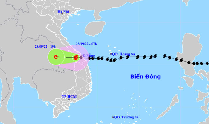
Forecast path and affected areas of Storm Noru at 7 AM on September 28. (Photo: NCHMF)
The sea area from Quảng Bình to Phú Yên (including Cồn Cỏ Island, Cù Lao Chàm, and Lý Sơn) experienced strong winds at Categories 6-7, gusting to Categories 8-9; wave heights reached 2-4 meters, with strong sea disturbances.
On land, Thừa Thiên Huế, Da Nang, Quảng Nam, Quảng Ngãi, Bình Định, and Gia Lai experienced winds of Categories 6-7, with areas near the storm’s center experiencing winds at Category 8, gusting to Category 10; Quảng Bình, Quảng Trị, Phú Yên, and Kon Tum recorded winds of Category 6, gusting to Category 8.
Today, Quảng Trị, Thừa Thiên Huế, Da Nang, Quảng Nam, Quảng Ngãi, and Kon Tum are expected to receive heavy rainfall of 100-150 mm, with some areas exceeding 200 mm; Quảng Bình, Bình Định, and Gia Lai will see rainfall of 40-80 mm, with some areas exceeding 120 mm.
Today and tomorrow, North Central Vietnam is forecasted to receive rainfall of 100-250 mm, with some areas exceeding 300 mm; coastal areas, the Red River Delta, and Hòa Bình will generally see rainfall of 70-150 mm, with some areas exceeding 180 mm.
8:20 AM: Many roofs blown off in Da Nang
On Hoàng Sa Street in Da Nang, roofs were blown off and fell onto the road. The goalposts at Mân Thái beach were pushed onto the street by the waves.
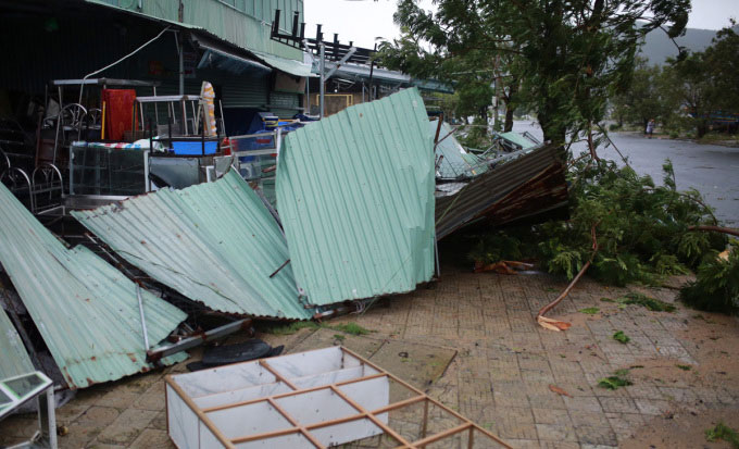
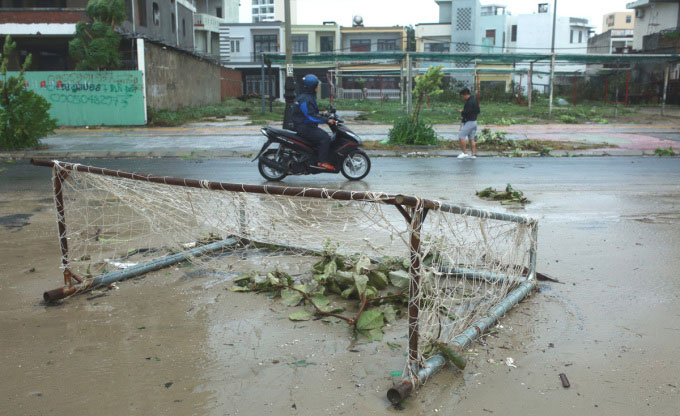
Photo: Nguyễn Đông
8:10 AM: Hoi An’s ancient town littered with fallen trees
In Hoi An’s ancient town, many old trees lost their tops, falling onto power and telecommunications lines. Some newly planted small trees were uprooted, blocking the roads.
The streets remained deserted as residents had not yet returned home after sheltering from the storm overnight.
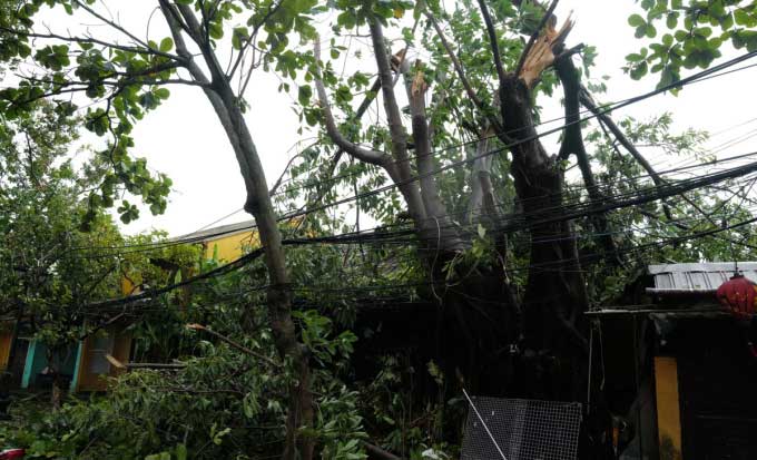
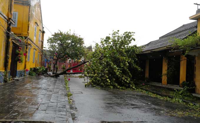
Photo: Ngọc Thành
8:00 AM: Thừa Thiên Huế: Many coastal houses lose roofs
In Vinh Xuân commune, Phú Vang district, many houses with metal roofs were stripped bare by the storm winds; tiled roofs were blown off.
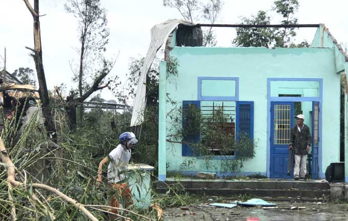

Photo: Võ Thạnh
7:30 AM: Hue concerned about high tide
Located at the edge of the storm’s eye, Hue City and some coastal areas experienced intermittent heavy rain and wind, with some trees uprooted, but not in large numbers. Police and military patrols were deployed to clear fallen trees from the roads.
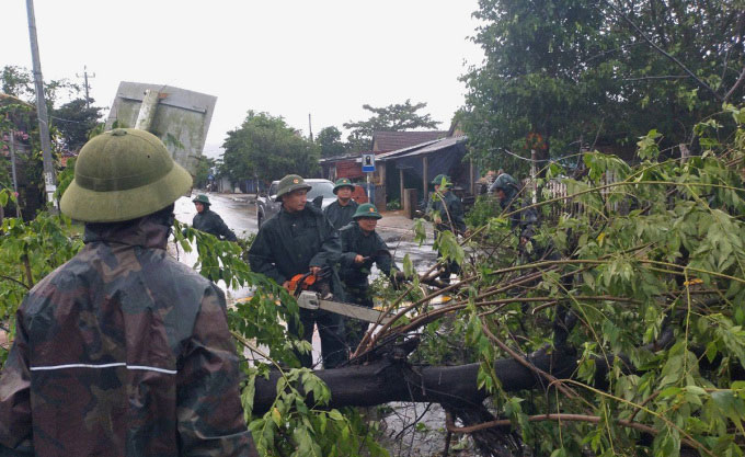
Authorities clearing fallen trees in Hue City. (Photo: Võ Thạnh).
Mr. Phan Thanh Hùng, Chief of the Office of the Thừa Thiên Huế Steering Committee for Disaster Prevention and Search and Rescue, stated that the storm’s residual effects are expected to last until 10 AM. Local concerns now focus on coastal areas, particularly at Thuận An and Tư Hiền, which are at risk of flooding and isolation due to heavy rain. Some areas near Tam Giang and Cầu Hai are experiencing tidal flooding over the dams.
Currently, Deputy Prime Minister Lê Văn Thành and a working delegation are inspecting the situation in Thuận An town (Hue City) and Phú Thuận commune (Phú Vang district).
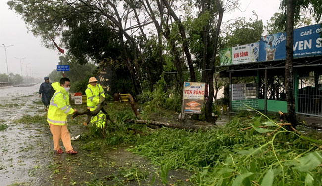
The area near Nước Ngọt Bridge, Lộc Thủy commune, Phú Lộc district, where trees about 10 years old were uprooted. (Photo: Võ Thạnh).
7:15 AM: Many roads in Kon Tum cut off
This morning, Kon Tum province began experiencing heavy rain. Many inter-commune concrete roads in Tu Mơ Rông district were cut off due to floodwaters. Some areas experienced landslides and fallen trees, making travel impossible for residents.
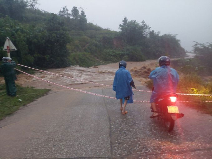
Authorities blocking a road section due to floodwaters on the morning of September 28. (Photo: Trần Hoá).
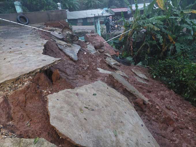
Heavy rain causing landslides in several areas of Tu Mơ Rông district. (Photo: Trần Hoá).
7:00 AM: Residents of Quảng Ngãi return home after evacuating
Initially forecasted as the storm’s center, on September 28, Storm Noru deviated towards Quảng Nam and Da Nang, resulting in minimal impact on Quảng Ngãi. This morning, about 1,500 residents from Bình Đông commune, Bình Sơn district, who evacuated from the storm, returned home. They were relieved to learn that their coastal homes had not suffered significant damage. Previously, the province had planned to evacuate 10,000 households to avoid the storm.

Residents of Bình Đông commune, Bình Sơn district returning home on the morning of September 28. (Photo: Phạm Linh)
7:00 AM: Streets of Da Nang littered
Numerous barriers and trees were knocked down by the wind, leaving the streets of Da Nang cluttered this morning.
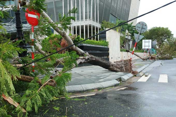
A fallen tree on Lý Tự Trọng Street, at the intersection with Bạch Đằng along the Han River, on the morning of September 28. (Photo: Nguyễn Đông).
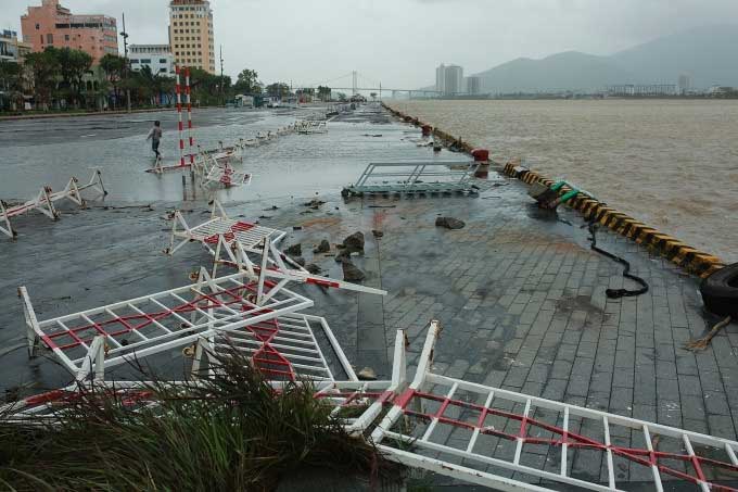
A row of barriers at the yacht harbor on Bạch Đằng Street blown down. (Photo: Nguyễn Đông).
6:30 AM: Tam Kỳ City devastated by the storm
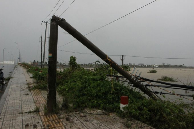
A power pole in Tam Kỳ City knocked down by the wind. (Photo: Đắc Thành).
6:15 AM
On National Highway 24 in Quảng Ngãi, traffic police are cutting down fallen trees and clearing the road to ensure safe passage for vehicles and residents after the storm. The Traffic Police Department has directed police in the provinces to reopen roads for vehicle passage by 6:30 AM. However, police will regulate vehicle movement in batches, allowing one group of vehicles to pass every 15 minutes to prevent congestion.
Traffic police in Quảng Ngãi cutting down fallen trees and clearing the road. Photo: CSGT
6:10 AM: Streets of Hoi An flooded, trees down
6:00 AM: Over 40 households in Hue remain isolated
In coastal areas of Thừa Thiên Huế, strong winds and heavy rain continued. The Thuận An estuary area experienced high waves. More than 40 households in Hương Giang hamlet remain isolated due to rising tides.
5:40 AM: Recommendation for students to take a day off on September 28
Mr. Hoàng Đức Cường, Deputy General Director of the Meteorology and Hydrometeorology Department (Ministry of Natural Resources and Environment), stated that around 4 AM today, the storm’s eye made landfall between Quảng Nam and Da Nang, reducing to Categories 11-12. The strongest winds recorded at Cù Lao Chàm were Category 14. Currently, on land, particularly in Quảng Nam, winds of Category 9, gusting to Category 12 have been observed.
As the storm made landfall, the area of gusting winds gradually shrank, moving north towards Quảng Nam and south towards Da Nang, then up towards Kon Tum, weakening into a tropical depression. Currently, the coastal area of Quảng Nam recorded the strongest winds at Category 9, gusting to Category 12.
By 5:30 AM, this area only had winds of Category 6, gusting to Category 7, which will persist until around 8-9 AM, then gradually decrease. By around noon, Quảng Nam and Da Nang will see a reduction in strong coastal winds. As the storm moves inland to the Central Highlands, only gusts will remain. Rainfall will also decrease to between 100 and 150 mm.
Despite this, authorities still recommend continuing to keep students home today; additionally, fishermen are not allowed to go out to sea due to high waves; mountainous areas need to be cautious of flash floods and landslides.
Deputy Prime Minister Le Van Thanh has urged that although the storm has weakened, people should not be complacent, as history has shown that many have not perished in the storm itself but rather in the subsequent floods. He also agreed that schools should not rush to resume classes. Educational institutions should reassess their facilities and infrastructure. Local authorities must continue to monitor the storm and flood situation, remaining vigilant and not neglectful. During this calm period, localities need to promptly inspect identified risk areas, such as in Da Nang, where 60 fishermen chose to stay on their boats overnight.
