Typhoon No. 2 has intensified by one level and is continuing its movement toward the mainland of Vietnam, bringing heavy rain to the northern provinces from this evening (August 10).
According to the National Center for Hydro-Meteorological Forecasting, at 10 AM today (August 10), Typhoon No. 2, named Mulan, was located in the northeastern region of Hainan Island (China), approximately 350 km to the east-northeast of Bach Long Vi Island. The strongest winds near the center of the typhoon have increased to level 9 (62-88 km/h), with gusts reaching level 11. The radius of strong winds at level 6, with gusts of level 8, extends about 130 km from the typhoon’s center.
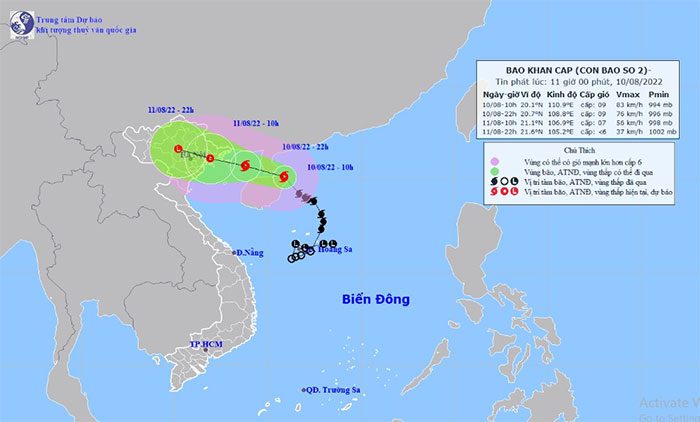
Position and next movement direction of Typhoon No. 2 Mulan. (Photo: National Hydro-Meteorological Forecasting Center).
Forecast for the next 12 hours: the typhoon is moving in a west-northwest direction, traveling at a speed of 15-20 km/h.
By 10 PM on August 10, the center of the typhoon is expected to be located in the northern Gulf of Tonkin, about 130 km southeast of Mong Cai (Quang Ninh), approximately 220 km east of Hai Phong, and around 240 km east of Thai Binh. The strongest winds near the typhoon’s center are forecasted to be at level 8 (62-74 km/h), with gusts reaching level 10.
Forecast for the next 12 to 24 hours: the typhoon will continue moving west-northwest at a speed of 15-20 km/h, making landfall in the northern provinces before gradually weakening into a tropical depression.
By 10 AM on August 11, the center of the tropical depression is expected to be located over the northeastern provinces. The strongest winds near the center of the tropical depression are forecasted to be at levels 6-7 (39-61 km/h), with gusts reaching level 9.
In the next 24 to 30 hours, the tropical depression will move deeper inland and gradually weaken into a low-pressure area over the northern region. The strongest winds in the center of the low-pressure area will drop below level 6 (less than 39 km/h).
Due to the impact of Typhoon No. 2, the northeastern sea area (including the waters north of the Paracel Islands) will experience strong winds of levels 6-7, with winds near the typhoon’s center reaching levels 8-9, gusting to level 11, and wave heights of 4-6 meters, creating very rough seas.
The northern Gulf of Tonkin (including Co To Island and Bach Long Vi) will see winds gradually increasing to level 6, then rising to level 7, with winds near the typhoon’s center at level 8, gusting to level 10, and wave heights of 2-4 meters, leading to rough seas. Coastal provinces from Quang Ninh to Nam Dinh should be cautious of high waves combined with tidal surges causing flooding in low-lying areas.
Due to the strong southwest monsoon, the waters from Binh Dinh to Ca Mau, as well as the central and southern parts of the East Sea (including the Spratly Islands), will experience strong winds of level 6, occasionally reaching level 7, with gusts of level 9, and wave heights of 2-4 meters, resulting in rough seas.
Warnings of strong winds on land: on the night of August 10 and the morning of August 11, the coastal areas of Quang Ninh and Ninh Binh are likely to experience strong winds of levels 6-7, with gusts of level 9.
From this evening (August 10) until around August 12, the northern region, Thanh Hoa, and Nghe An are expected to experience moderate to heavy rain and thunderstorms, with some areas receiving very heavy rain of 100-200 mm per event, and some areas exceeding 250 mm per event.
